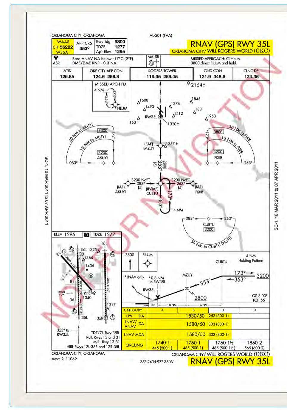
When GPS first arrived in the cockpit, it was a powerful tool for en route and terminal navigation, but it lacked the precision and integrity guarantees needed to shoot instrument approaches down to the lowest minimums. The Wide Area Augmentation System — universally known as WAAS — changed that equation dramatically. By broadcasting correction signals that tighten GPS accuracy and provide real-time monitoring of satellite health, WAAS elevated GPS from a supplemental navigation aid into a system capable of flying approaches with decision altitudes comparable to a Category I ILS. Understanding WAAS and the hierarchy of approach minimums it enables is essential both for passing the Instrument Rating knowledge test and for operating safely in the IFR environment.
This article walks through how WAAS works at a conceptual level, explains each type of GPS approach line of minimums, and highlights the practical and regulatory details that appear most often on FAA exams and in real-world cockpit decision-making.
How WAAS Works
Standard GPS — sometimes called GPS without augmentation, or non-WAAS GPS — relies solely on signals from the constellation of GNSS satellites orbiting the Earth. Under ideal conditions this produces horizontal accuracy of roughly 10–15 meters, which is adequate for en route navigation but falls short of approach requirements in two important ways: accuracy is not tight enough for vertical guidance down to low minimums, and the system cannot alert a pilot quickly enough if a satellite begins transmitting faulty data.
WAAS addresses both problems through a network of precisely surveyed Wide-Area Reference Stations (WRS) distributed across the United States and neighboring regions. Because these ground stations know their exact position, they can measure any error in the GPS signal they receive. Those error measurements are forwarded to Wide-Area Master Stations (WMS), which compute differential corrections and, critically, generate a signal-in-space integrity message that tells the airborne receiver whether each satellite is safe to use. The corrected data is then uplinked to geostationary satellites — the WAAS satellites you will see listed as pseudo-random noise (PRN) codes on your avionics — which re-broadcast the augmented signal on the same frequency (L1, 1575.42 MHz) as the GPS constellation itself.
The result is typical horizontal accuracy better than 1 meter and vertical accuracy in the 1–3 meter range, with an integrity alarm that fires within 6 seconds if the system detects a problem. That combination of accuracy and rapid integrity monitoring is what allows WAAS to support vertically guided approaches.
The Hierarchy of GPS Approach Minimums
A single GPS or RNAV (GPS) approach plate can contain up to four distinct lines of minimums, each reflecting a different level of system capability. They appear on the chart from best to worst performance, top to bottom. A WAAS-capable avionics unit, properly certified and current, may be able to fly any of these lines depending on real-time signal availability.
LPV — Localizer Performance with Vertical Guidance
LPV is the premium WAAS service level and represents the closest GPS equivalent to an ILS. It provides both lateral and vertical course guidance with angular scaling similar to a localizer and glideslope. LPV approaches are published with a Decision Altitude (DA) — the same concept used for ILS approaches — and minimums can be as low as 200 feet Height Above Touchdown (HAT) with a half-mile (2,400 feet runway visual range) visibility, matching Category I ILS limits. Not every LPV reaches 200 feet; terrain, obstacles, and other factors may place the DA higher, but 200/½ is achievable and increasingly common.
For LPV to be available, the WAAS signal must meet stringent accuracy and integrity standards at the moment of the approach. The avionics annunciator will display LPV as the active approach mode when these standards are met. If WAAS signal quality degrades, the receiver may automatically downgrade to a lower service level — a transition pilots must anticipate.
LNAV/VNAV — Lateral Navigation / Vertical Navigation
LNAV/VNAV provides lateral guidance equivalent to an LNAV approach but adds advisory or approved vertical path guidance using either WAAS or barometric vertical navigation (Baro-VNAV). The vertical component here does not meet the full integrity standards of LPV, so minimums are higher — typically a DA in the range of 250 to 400 feet HAT, though the exact value is chart-specific. Baro-VNAV is temperature-sensitive and may not be authorized when the airport temperature falls below a published limit; WAAS-based LNAV/VNAV does not carry that restriction. LNAV/VNAV uses a Decision Altitude, not a Minimum Descent Altitude, because vertical guidance is continuous throughout the approach.
LNAV — Lateral Navigation Only
LNAV is a non-precision approach in the traditional sense: it provides only lateral (horizontal) course guidance, with no electronic vertical path. The pilot descends using step-down fixes or a constant-angle visual descent to the Minimum Descent Altitude (MDA), then must see the runway environment before descending further. LNAV minimums are higher than LPV or LNAV/VNAV — often 300 to 500 feet or more above the touchdown zone — and visibility requirements are correspondingly greater. LNAV can be flown by both WAAS and non-WAAS IFR-approved GPS receivers, making it the baseline GPS approach capability.
LP — Localizer Performance (Without Vertical Guidance)
LP is a WAAS-only service level that provides high-accuracy lateral guidance (similar to a localizer in angular scaling) without a vertical path. It uses an MDA and is published at airports where vertical guidance cannot be provided but where WAAS accuracy allows tighter lateral minimums than standard LNAV. LP is less common than the other types but may appear on specific approach plates and on the knowledge test.
Avionics Certification and Currency Requirements
Not every GPS or RNAV navigator in an aircraft is WAAS-capable, and not every WAAS receiver is certified for all service levels. TSO-C145 and TSO-C146 are the FAA Technical Standard Orders that govern WAAS avionics. A receiver certified under these TSOs — when installed per the applicable Supplemental Type Certificate or Aircraft Flight Manual Supplement — is authorized to fly LPV and other WAAS-based minimums. An older GPS certified under TSO-C129 is a non-WAAS receiver and is limited to LNAV minimums regardless of WAAS signal availability.
The database currency requirement under 14 CFR 91.171 (for VOR checks) does not directly govern GPS, but FAA guidance makes clear that the navigation database must be current for IFR flight using GPS as primary navigation. An expired database means the approach data may not reflect the latest obstacle surveys, missed approach waypoints, or procedure changes — a serious safety and regulatory issue.
Why WAAS Minimums Matter in the Real World
The practical impact of WAAS on general aviation has been enormous. Thousands of airports across the United States that never had ILS infrastructure — and many that never could, due to terrain or cost — now have LPV approaches published with 200-foot decision altitudes. The FAA reports more LPV approach procedures in the U.S. than ILS procedures, making WAAS-based LPV the most prevalent precision-equivalent approach in the country.
For the IFR pilot, this translates directly into access. On a marginal day with a 300-foot overcast, an airport with only LNAV minimums at 400 feet HAT is off-limits, while that same airport with an LPV minimum of 200 feet HAT may be perfectly legal and safe. Understanding which line of minimums your avionics is authorized and able to fly — and confirming the annunciator shows that service level before commencing the approach — is a real-world safety skill, not just test preparation.
Key Numbers and Rules
- LPV DA minimum: as low as 200 feet HAT / RVR 2400 (½ SM visibility), equivalent to Category I ILS limits.
- LNAV/VNAV: uses a Decision Altitude; minimums typically higher than LPV; temperature limits may apply to Baro-VNAV.
- LNAV: uses a Minimum Descent Altitude; available to both WAAS and non-WAAS IFR-approved GPS receivers.
- LP: WAAS-only lateral approach with MDA; no vertical guidance; tighter lateral accuracy than standard LNAV.
- WAAS accuracy: typically better than 1 meter horizontal, 1–3 meters vertical under normal conditions.
- WAAS integrity alarm: within 6 seconds of detecting a satellite anomaly.
- Governing TSOs: TSO-C145/C146 for WAAS; TSO-C129 for non-WAAS GPS (LNAV only).
- Automatic downgrade: if WAAS signal quality is insufficient for LPV, the avionics will annunciate a lower service level; always confirm the displayed mode before the final approach fix.
Common Test Traps
- LPV is not an ILS. It produces ILS-like performance, but it uses GPS/WAAS signals. Do not confuse an LPV DA with an ILS decision height or imply the same equipment is used.
- LPV uses a DA, not an MDA. LNAV uses an MDA. LNAV/VNAV uses a DA. LP uses an MDA. The test will mix these up — know which type uses which altitude concept.
- Non-WAAS GPS cannot fly LPV or LP. A TSO-C129 receiver is limited to LNAV minimums on a GPS approach, full stop.
- Annunciator confirmation is mandatory. The fact that an LPV approach is charted does not mean the service level is available right now. The avionics must annunciate LPV for the pilot to use LPV minimums. If it shows LNAV, fly LNAV minimums.
- Database currency is a real requirement. An expired navigation database is not just a paperwork issue — using it for an IFR approach raises both safety and regulatory concerns even if the GPS hardware is fully functional.