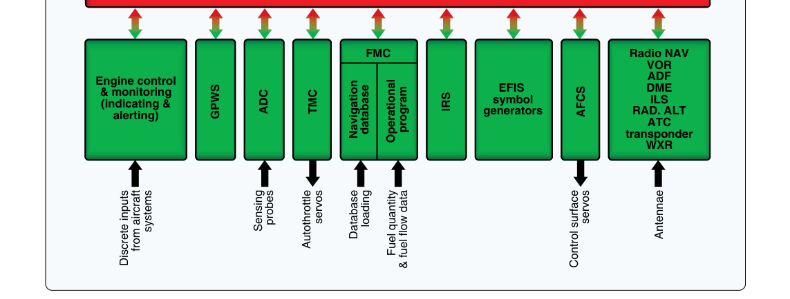
Modern instrument flying increasingly relies on the Flight Management System, or FMS, to automate and integrate navigation across the entire flight. At its core, the FMS is a sophisticated computer that blends data from multiple sensors — GPS receivers, VOR/DME stations, inertial reference units, and air data computers — to compute the aircraft's precise position and then guide it along a pre-defined route both laterally and vertically. Understanding how lateral navigation (LNAV) and vertical navigation (VNAV) work, and how they interact, is essential for any instrument-rated pilot operating in the modern National Airspace System.
For the IFR knowledge test and, more importantly, for real-world safety, you must understand not just how to push the buttons but what the FMS is actually doing at every phase of flight, where its limitations lie, and how to remain the pilot in command of a system that can quietly drift off course or descend at the wrong moment if you stop monitoring it.
What the FMS Actually Does
Think of the FMS as the brain behind area navigation (RNAV). It stores a database of waypoints, airways, airports, instrument procedures, and navigation aid locations. When you build a flight plan in the FMS — or load a departure, arrival, or approach procedure — the system constructs a continuous string of waypoints called the active route. It then continuously computes your position relative to that route and issues steering commands to the autopilot or flight director to keep you on track.
The FMS does this by sensor fusion. A GPS receiver provides the primary position solution in most modern installations, but the FMS cross-checks and blends that with DME/DME or VOR/DME data where available, improving accuracy and providing redundancy. The result is a position estimate that is typically far more accurate and reliable than any single sensor alone. The FMS then projects that position onto the active route and calculates two fundamental error values: cross-track error (XTK) for lateral guidance, and vertical deviation for VNAV guidance.
Lateral Navigation (LNAV) in Depth
LNAV is the FMS function that keeps the aircraft on the published horizontal track. It computes the great-circle path between successive waypoints, accounts for wind by adjusting the commanded heading, and provides a continuous course deviation signal that the autopilot or flight director follows. On a control display unit (CDU) or multifunction display you will typically see cross-track error expressed in nautical miles or tenths of a mile.
In the en route environment, LNAV keeps the aircraft on the centerline of an RNAV route or a direct-to waypoint with lateral accuracy that far exceeds traditional VOR tracking. The required navigation performance (RNP) concept formalizes this: en route RNAV typically requires Total System Error (TSE) within 2 nautical miles 95% of the time. Terminal area operations require tighter tolerances, and RNAV approach operations tighten the requirement further.
On an RNAV (GPS) approach, LNAV provides lateral guidance to the runway centerline extended. The published LNAV minima have a wider obstacle clearance surface because the approach is non-precision in character — there is no glideslope. The pilot descends in steps to the minimum descent altitude (MDA) and then looks for the runway environment. LNAV alone supports a straight-in approach with lateral steering, but the pilot manually manages the vertical profile using step-down fixes or a published constant-angle non-precision approach (CANPA) technique.
A critical sub-category is LNAV/VNAV, which pairs the lateral steering of LNAV with a computed vertical path — but this combination uses barometric altitude, not a radio-based glideslope, to define the descent angle. More on this in the VNAV section below.
Vertical Navigation (VNAV) in Depth
VNAV is the FMS function that manages the aircraft's vertical profile along the route. It constructs a three-dimensional path through altitude constraints — crossing restrictions on SIDs and STARs, step-down fixes on approaches, the final approach vertical path — and computes the required vertical speed or flight path angle to meet each constraint. When coupled to the autopilot, VNAV can automatically initiate descents, capture altitude restrictions, and fly a final approach descent path.
There are two fundamentally different types of VNAV in common use, and confusing them is a significant safety trap:
- Baro-VNAV: The FMS computes the vertical path purely from barometric altitude data. It calculates a geometric descent angle (typically 3 degrees) and converts that angle to an altitude profile referenced to the altimeter setting at the destination. This is the type used on LNAV/VNAV minima and on many LP+V and LNAV/VNAV approach procedures. Because it depends on barometric altitude, it is sensitive to temperature errors — in very cold weather, the true altitude is lower than the indicated altitude, which can cause the aircraft to fly below the protected obstacle clearance surface.
- SBAS/LPV (Satellite-Based Augmentation System): When the aircraft is equipped with a WAAS GPS receiver and the approach is published with LPV (Localizer Performance with Vertical Guidance) minima, the vertical path is derived directly from the GPS solution augmented by WAAS corrections. This provides an accurate geometric glidepath independent of barometric error. LPV approaches can have decision altitudes (DAs) as low as 200 feet HAT, comparable to a Category I ILS.
On a STAR or SID with altitude crossing restrictions, VNAV will sequence through those constraints automatically if they are loaded from the procedure database. However, the FMS may compute an advisory VNAV path only — meaning it shows you the vertical deviation but the autopilot altitude preselect still governs. You must understand your specific aircraft's FMS logic: some systems require you to arm VNAV explicitly, others sequence automatically, and some cannot honor constraints that are expressed as a window ("at or above/at or below") without pilot input.
LNAV/VNAV Approach Operations
The RNAV (GPS) approach chart often contains multiple lines of minima: GLS, LPV, LNAV/VNAV, LNAV, and sometimes circling. Understanding which set of minima applies to your aircraft and avionics is critical.
- LPV minima require a WAAS-capable GPS receiver providing full LPV guidance. The DA is used, not MDA.
- LNAV/VNAV minima require a baro-VNAV capable FMS. The DA is used. Cold weather corrections may apply — check the approach plate notes and the AIM for temperature correction requirements, because in temperatures below the published limit, baro-VNAV may not be authorized without adding a cold-temperature correction to the DA.
- LNAV minima are available to any RNAV-capable aircraft. The MDA is used and the vertical path is not provided by the approach itself (though the FMS may still show an advisory glidepath).
At the final approach fix (FAF), the FMS sequences to approach mode, which tightens the lateral scaling from terminal sensitivity (typically ±1 NM full-scale deflection) to approach sensitivity (±0.3 NM full-scale deflection), and then narrows further to ±0.1 NM at the runway threshold. This automatic scaling change means the CDI becomes far more sensitive as you approach the runway — a full deflection represents only 600 feet at the threshold — so even small cross-track errors produce large needle deflections.
Why It Matters for Safety
The FMS makes precise 3D navigation available on nearly every IFR flight, dramatically reducing controlled flight into terrain (CFIT) accidents and enabling approaches to thousands of runways that never had ILS equipment. However, the same automation that helps can also create subtle hazards. A loaded but incorrect procedure, an outdated navigation database, or a misunderstood constraint can lead the aircraft precisely to the wrong place. The FAA emphasizes that RNAV procedures must be flown with current navigation databases — typically updated every 28 days — and that pilots must verify the loaded procedure against the published chart before every approach.
Automation complacency is the dominant human factors risk. Studies and accident reports consistently show that pilots who over-trust the FMS stop cross-checking raw data, stop monitoring altitude constraints, and fail to notice when the system has sequenced incorrectly or entered a mode they did not expect. The instrument pilot must remain mentally ahead of the FMS at all times.
Key Numbers and Rules
- En route RNAV accuracy requirement: 2 NM total system error, 95% of the time (RNP 2).
- Terminal RNAV accuracy requirement: 1 NM (RNP 1).
- RNAV approach lateral accuracy (LNAV): 0.3 NM full-scale CDI at the FAF, scaling to 0.1 NM at threshold.
- LPV approaches can publish DAs as low as 200 feet HAT, equivalent to Cat I ILS.
- Baro-VNAV cold temperature limits are published on approach charts; below those temperatures, the procedure is not authorized without corrections per the AIM temperature correction table.
- Navigation databases must be current — the standard AIRAC cycle is 28 days.
- Flying an LNAV/VNAV or LPV approach uses a Decision Altitude (DA), not an MDA; the pilot must execute a missed approach if the runway environment is not in sight at DA.
Memory Aid
"GPS Gives Lateral; WAAS Adds Vertical" — This phrase reminds you that basic GPS (without SBAS/WAAS) supports only lateral LNAV guidance. It takes WAAS augmentation to provide a certified geometric vertical path for LPV minima. Baro-VNAV fills the middle ground: it adds a vertical path computed from your altimeter, but it is temperature-sensitive and not geometrically referenced to the ground.
Common Test Traps
- Confusing MDA vs. DA on RNAV approaches: LNAV minima use an MDA (you may descend to and fly at that altitude looking for the runway). LPV and LNAV/VNAV minima use a DA — you must initiate the missed approach if not visual at that altitude, just like an ILS.
- Assuming any GPS equals LPV capability: Only a WAAS-enabled GPS receiver can fly to LPV minima. A non-WAAS GPS is limited to LNAV. The avionics must annunciate "LPV" on the approach mode display to confirm LPV guidance is active.
- Ignoring cold-temperature baro-VNAV restrictions: If the outside air temperature is below the limit published on the approach chart, baro-VNAV is not authorized at that temperature without applying the AIM cold-temperature altitude correction — a frequently tested and safety-critical point.
- CDI sensitivity change at the FAF: Students often do not expect the CDI to suddenly become much more sensitive as the FMS transitions from terminal to approach mode. This catches pilots who are not actively monitoring the approach and can lead to perceived "unstable" guidance that is actually the system working correctly.
- Database currency: Using an out-of-date navigation database is not just an FAA compliance issue — procedures change, and flying an outdated approach could mean flying an obstacle clearance surface that no longer reflects current terrain or construction.