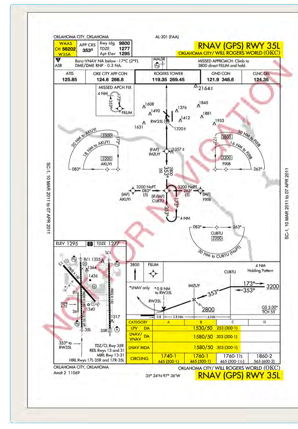
When you fly a GPS-based instrument approach, the minimums published on the approach plate are not one-size-fits-all. Depending on the capability of your aircraft's avionics and the integrity of the GPS signal at the time of the approach, you may be authorized to fly to one of four distinct sets of minimums: LNAV, LNAV/VNAV, LPV, or LP. Each line on the plate represents a different level of navigation performance, a different type of vertical guidance (or none at all), and a different Decision Altitude or Minimum Descent Altitude. Understanding what separates these four types is not just an exam topic — it directly determines how low you can legally descend in instrument meteorological conditions and how you must configure your avionics before the approach begins.
All four minimums lines live on RNAV (GPS) approach charts, a format that replaced the older stand-alone GPS approach chart. The key to sorting out the minimums is understanding two underlying technologies: the Wide Area Augmentation System (WAAS) and the concept of Required Navigation Performance (RNP). With that foundation in place, each minimums type becomes easy to understand logically rather than just memorize.
The Role of WAAS and GPS Signal Integrity
Standard GPS alone provides accuracy sufficient for en route and terminal navigation, but its natural errors — satellite geometry, atmospheric delays, and signal noise — are too large for precision approach operations. The FAA's Wide Area Augmentation System corrects these errors in real time by broadcasting correction signals from ground reference stations through geostationary satellites. A WAAS-enabled GPS receiver can achieve lateral accuracy on the order of 3 meters or better, and — critically — it can also provide reliable vertical guidance. Non-WAAS GPS receivers can navigate laterally with sufficient accuracy for an LNAV approach but cannot generate the certified vertical path required for LNAV/VNAV, LPV, or LP operations as an instrument approach.
Another concept underpinning RNAV approaches is Receiver Autonomous Integrity Monitoring (RAIM). Your GPS continuously checks the consistency of satellite signals to ensure the navigation solution is trustworthy. For WAAS receivers, the geostationary satellites also broadcast integrity information. If the system detects that it cannot meet the required accuracy and integrity for the approach being flown, it will alert you — and you must treat that as a missed approach situation if you have already commenced the approach.
LNAV: Lateral Navigation Only
LNAV (Lateral Navigation) minimums are the baseline GPS approach and the only type available to pilots flying a non-WAAS GPS receiver. LNAV provides lateral course guidance only — the GPS draws you accurately down the final approach course, but it provides no FAA-certified vertical descent path. Because there is no approved vertical guidance, LNAV is a non-precision approach (NPA), and its lowest authorized altitude is expressed as a Minimum Descent Altitude (MDA) rather than a Decision Altitude (DA).
Flying to LNAV minimums, you level off at the MDA and continue until you either identify the runway environment or reach the Missed Approach Point (MAP), just as you would on a traditional VOR approach. LNAV minimums are the highest (least favorable) of the four lines — typically 300–500 feet AGL or more above the runway — because without vertical guidance the approach must account for terrain and obstacle clearance without the precision that a defined glidepath provides.
Practically speaking, LNAV approaches also support a technique called Constant Angle Non-Precision Approach (CANPA), where the pilot uses an advisory vertical descent angle (often shown as a dashed line on the moving map or a VNAV advisory from the FMS) to fly a stabilized descent. This is advisory only and does not upgrade the minimums — you are still flying to the MDA.
LNAV/VNAV: Lateral and Vertical Navigation
LNAV/VNAV combines lateral GPS guidance with a barometric vertical navigation path (Baro-VNAV). The vertical path is generated by the aircraft's flight management system using barometric altitude data, not WAAS. Because it provides an approved vertical path, LNAV/VNAV is classified as an Approach with Vertical Guidance (APV) — a category that sits between traditional non-precision approaches and precision ILS approaches. The minimums are expressed as a Decision Altitude (DA), meaning you must make a fly/miss decision at that altitude rather than leveling off.
LNAV/VNAV can be flown with either a WAAS GPS receiver or, independently, an IFR-approved barometric VNAV system — either qualifies on its own. The catch with Baro-VNAV is that barometric altimetry degrades in very cold temperatures. Cold, dense air causes a barometric altimeter to read higher than actual altitude, meaning the aircraft may be lower than indicated. For this reason, temperature corrections must be applied (or the approach must not be flown) when the reported temperature is below the temperature limits published on some charts. WAAS-based LNAV/VNAV avoids this problem because the vertical guidance is satellite-derived, not barometric.
LNAV/VNAV minimums are typically lower than straight LNAV minimums — often in the 250–350 foot DA range — because the defined glidepath allows more precise obstacle clearance.
LPV: Localizer Performance with Vertical Guidance
LPV (Localizer Performance with Vertical Guidance) is the premium WAAS approach type and the one that most closely resembles an ILS in terms of crew experience and minimums. LPV uses WAAS satellite corrections to provide both lateral and vertical guidance, and the lateral accuracy scales from full-width at the FAF to a narrow angular width at the threshold — just like an ILS localizer, hence the name.
LPV is still classified as an APV approach rather than a precision approach under ICAO definitions (because it is not an ILS), but the FAA's practical rules treat it very similarly. LPV minimums are expressed as a Decision Altitude (DA). At airports with very good WAAS signal geometry and favorable terrain, LPV minimums can be as low as 200 feet HAT (Height Above Touchdown) with a half-mile visibility — identical to a Category I ILS. This makes LPV the most powerful tool in the GPS approach toolkit.
To fly LPV minimums, you must have a WAAS-enabled GPS receiver that is certified for LPV operations (confirmed in the avionics documentation and the aircraft's AFM supplement). The avionics must annunciate LPV on the approach mode display before you cross the Final Approach Fix. If the system downgrades to LNAV+V or LNAV before the FAF due to WAAS signal integrity, you must fly to the applicable LNAV minimums.
LP: Localizer Performance (No Vertical Guidance)
LP (Localizer Performance) is essentially the lateral-only counterpart to LPV. It uses WAAS precision to achieve very tight lateral accuracy — comparable to ILS localizer performance — but publishes no vertical guidance. Like LNAV, LP uses a Minimum Descent Altitude (MDA) and is technically a non-precision approach. LP minimums are typically published at locations where siting criteria or terrain/obstacles prevent the design of a vertically guided LPV glidepath, but WAAS lateral accuracy can still tighten the course considerably.
LP minimums are typically lower than or equal to LNAV minimums at the same airport, because the superior lateral accuracy of WAAS allows a narrower obstacle evaluation area, though this is not guaranteed at every airport. LP requires a WAAS receiver certified for LP operations. Not all WAAS receivers support LP; check the avionics supplement.
Key Numbers and Rules
- LNAV: Non-precision, MDA, lateral GPS only; available with non-WAAS IFR GPS receivers; highest minimums of the four types.
- LNAV/VNAV: APV, DA, lateral GPS + baro-VNAV; requires WAAS or certified Baro-VNAV; temperature corrections may apply; middle-tier minimums.
- LPV: APV, DA, full WAAS lateral and vertical; requires WAAS-certified avionics with LPV annunciation; can reach 200-foot DA / ½-mile visibility minimums; best available GPS minimums.
- LP: Non-precision, MDA, WAAS lateral only; no vertical guidance; requires WAAS receiver certified for LP; lower than LNAV but still an MDA approach.
- The avionics must annunciate the specific approach mode (LPV, LNAV/VNAV, LP, LNAV) before the FAF; you may not fly to minimums lower than what the system has armed.
- WAAS availability is not guaranteed; always have LNAV as an alternate plan before beginning an RNAV approach.
- Baro-VNAV cold-temperature errors: when outside air temperature is very cold (limits are approach-specific), the indicated MDA/DA may place you lower than published obstacle clearance. Check published temperature limits.
Why It Matters
Misidentifying which minimums apply — or assuming you can fly to LPV minimums when your avionics have downgraded to LNAV — is a safety-critical error. Flying below an MDA without visual contact with the runway environment, or descending below a DA without identifying the required visual references, violates 14 CFR § 91.175 and puts the aircraft in immediate danger. The hierarchy matters: you are never permitted to use minimums lower than what the avionics have confirmed and annunciated for the approach in progress.
From a practical standpoint, LPV minimums open airports that would otherwise be below ILS capability — many regional airports now have LPV approaches with 200-foot DAs, effectively giving WAAS-equipped GA pilots near-Cat I access without the expense of an ILS installation. This dramatically expands where you can fly safely in low-IFR conditions.
Common Test Traps
- DA vs. MDA confusion: LNAV and LP use MDAs (level off and continue). LNAV/VNAV and LPV use DAs (decision point, then fly or miss). The test will ask which is which.
- Assuming LPV = precision approach: LPV is an APV — approach with vertical guidance — not an ICAO Category I precision approach. However, its minimums can equal those of a Cat I ILS.
- Non-WAAS receiver limitations: A non-WAAS IFR GPS can only use LNAV minimums. It cannot fly LNAV/VNAV (WAAS-based), LPV, or LP, even if those lines are published on the chart.
- LNAV+V is advisory only: Some WAAS receivers display a vertical deviation needle labeled LNAV+V. This is an advisory path to help fly a stabilized approach to LNAV minimums — it does not authorize LNAV/VNAV or LPV minimums. The approach is still LNAV.
- Mode annunciation before the FAF: You must confirm the avionics display the intended approach mode prior to the Final Approach Fix. If the avionics cannot achieve LPV integrity, they will automatically downgrade and you must fly the downgraded minimums — you cannot select a lower minimums line manually.