When GPS became widely available for instrument flight, the FAA faced a practical problem: thousands of existing non-precision approaches had been designed around ground-based navaids like VOR and NDB. Rather than immediately create entirely new procedures, the agency first allowed GPS receivers to overlay those existing approaches — flying the same course, altitudes, and fixes, but using satellite navigation instead of a ground station. Later, as GPS maturity grew, the FAA began publishing procedures designed from the ground up specifically for area navigation. Today, pilots encounter both types in the real world, and the FAA knowledge test expects you to know the difference, the limitations, and the currency requirements of each.
This article unpacks the two categories, explains how each is authorized, clarifies what equipment you need, and highlights the critical legal and practical distinctions that trip up instrument students on both the written exam and checkrides.
The Overlay Approach: GPS Standing In for a Ground-Based Navaid
An overlay approach is an existing instrument approach procedure — originally designed for a VOR, VOR/DME, NDB, or similar navaid — that has been approved for use with GPS. You can recognize older overlay titles on approach charts because they used to read, for example, "VOR or GPS RWY 28." FAA chart reform eventually moved toward naming these approaches "RNAV (GPS) RWY 28," but the underlying design geometry still mirrors the original ground-based procedure. The fixes, course alignments, stepdown altitudes, and missed approach instructions are all inherited from the legacy navaid design.
Because the original navaid's signal defined the course structure, overlay approaches often include fixes that were designed around the radial geometry of a VOR or the bearing geometry of an NDB. GPS receivers handle these easily with their internal databases, but the procedure was not optimized for satellite navigation. You may encounter fixes with awkward spacing, final approach courses that are not perfectly straight-in to the runway, or missed approach turns that made sense for a VOR station location but feel oddly placed when you are flying purely on GPS.
Underlying Navaid Requirement — A Critical Distinction
Here is where students frequently stumble. Under the original overlay authorization, regulations and FAA guidance required that the underlying ground-based navaid be operational and monitored during the approach — even though the pilot was navigating by GPS. The rationale was that GPS was still gaining regulatory trust, and the ground navaid served as an integrity backstop. Over time, as certified GPS equipment with RAIM (Receiver Autonomous Integrity Monitoring) became the norm, the FAA relaxed some of these requirements for properly certified WAAS and non-WAAS receivers. However, the Instrument Flying Handbook (FAA-H-8083-15) and the AIM still make clear that pilots must understand what their specific avionics approval authorizes. Always check your Pilot's Operating Handbook (POH) or Airplane Flight Manual Supplement (AFMS) for your GPS unit: it will specify whether the underlying navaid must be operational, monitored, or is entirely irrelevant for your installation.
The Standalone GPS Approach: Purpose-Built for Satellite Navigation
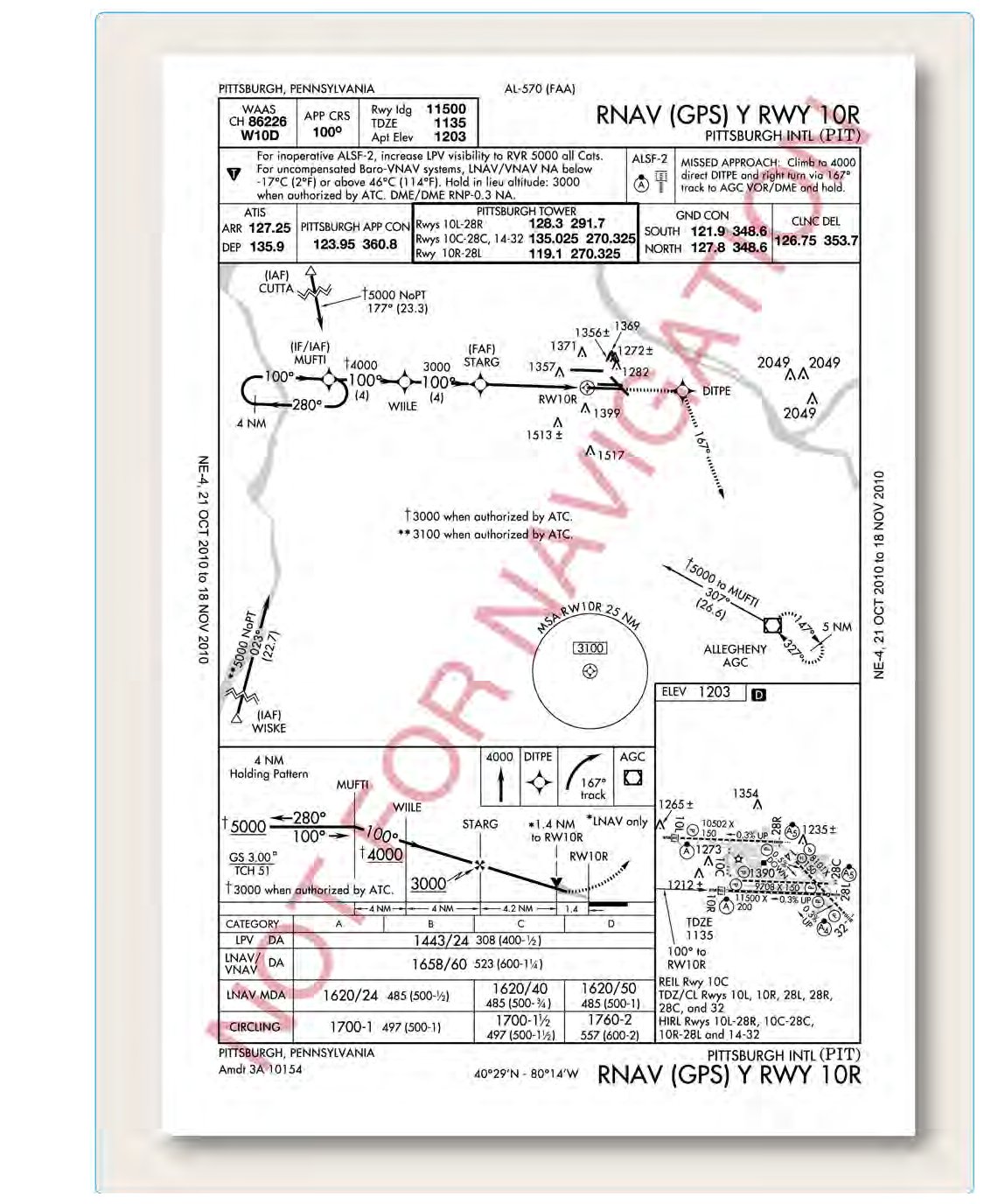
Standalone GPS approaches — now largely titled "RNAV (GPS) RWY XX" on charts — are procedures designed entirely around GPS and RNAV capability. The FAA's Terminal Instrument Procedures (TERPS) criteria for these approaches account for GPS antenna placement, RAIM availability, and WAAS augmentation from the very start. As a result, you will often see more optimally placed fixes, better final approach alignment, and — crucially — the addition of vertically guided minimums lines such as LPV (Localizer Performance with Vertical Guidance) and LNAV/VNAV, which are only possible on purpose-built procedures.
On a modern RNAV (GPS) chart, you may see several lines of minimums stacked below each other: LPV, LNAV/VNAV, LNAV, and sometimes LP (Localizer Performance). Each line corresponds to a different level of navigation integrity your equipment must be able to provide:
- LPV (Localizer Performance with Vertical Guidance): Requires a WAAS-enabled GPS receiver (TSO-C146 or equivalent). Provides both lateral and vertical guidance with angular deviation scaling similar to an ILS. Decision altitudes can be as low as 200 feet HAT — equivalent to a Category I ILS — but LPV is still an APV (Approach with Vertical Guidance), not a precision approach under ICAO/FAA definitions.
- LNAV/VNAV: Lateral navigation plus advisory vertical guidance. Can be flown with a WAAS receiver or with a non-WAAS receiver coupled to an approved barometric VNAV system, if the aircraft and avionics are approved for it. Uses a decision altitude (DA), not a minimum descent altitude (MDA).
- LNAV: Lateral navigation only. Available to all certified GPS receivers meeting TSO-C129 or TSO-C196 standards. Uses an MDA. This is the baseline non-precision equivalent — the most broadly accessible minimum line.
- LP (Localizer Performance): Lateral only, but with tighter accuracy than standard LNAV because it uses WAAS integrity. Appears on some approaches where vertical guidance cannot be provided due to terrain or obstacle constraints. Uses an MDA.
How Authorization Works: Equipment, Database, and RAIM
For any GPS approach — overlay or standalone — three fundamental requirements apply under 14 CFR and FAA guidance:
- Certified avionics: The GPS receiver must be certified to an appropriate TSO (TSO-C129 or TSO-C196 for non-WAAS, TSO-C145/C146 for WAAS) and installed per an FAA-approved avionics installation. A handheld portable GPS unit, regardless of its sophistication, is not legal for IFR approaches.
- Current navigation database: The approach must be loaded from the receiver's navigation database — you may not hand-fly a GPS approach by manually entering waypoints from a chart. The database must be current (28-day AIRAC cycle). This is a firm requirement found in the AIM and reinforced by IFH guidance.
- RAIM availability: For non-WAAS (TSO-C129/C196) GPS users, you must verify prior to the flight that RAIM will be available for the approach at your estimated time of arrival. The AIM describes methods for this, including FAA RAIM prediction tools and NOTAM checking. WAAS receivers generally do not require a separate RAIM prediction check, since WAAS provides its own integrity monitoring — though checking NOTAMs for WAAS outages is still advisable, as outages can affect approach minimums availability.
Why It Matters: Real-World and Safety Relevance
Understanding the difference between overlay and standalone procedures has immediate practical consequences. First, it affects your minimums. An overlay procedure was designed for a VOR or NDB, so its final approach course alignment, fix spacing, and obstacle clearance surfaces are calibrated for that navaid's characteristics. You will not find an LPV line on a VOR overlay — that level of vertical guidance only exists on purpose-designed RNAV procedures. Second, knowing the procedure type helps you interpret unusual fix placement or missed approach geometry that might otherwise seem like a charting error. Third, for flight planning, if RAIM is predicted to be unavailable or your GPS database is expired, you lose the ability to use the GPS approach legally — and if the underlying navaid is out of service on an overlay approach where it is required, that approach may be off the table entirely.
From an ADM (aeronautical decision-making) standpoint, a pilot who does not understand these distinctions may select an approach they are not legally authorized to fly, fly to minimums their equipment cannot legitimately support, or fail to brief a required ground navaid check-in before beginning the approach.
Key Numbers and Rules
- GPS navigation database must be current (within the 28-day AIRAC cycle) for legal IFR approach use.
- LPV decision altitudes can reach as low as 200 feet HAT — equivalent to CAT I ILS in terms of altitude, but LPV is classified as an APV, not a precision approach.
- RAIM prediction must be confirmed prior to departure for non-WAAS (TSO-C129/C196) GPS users when a GPS approach is the planned approach; check NOTAMs for GPS and WAAS outages.
- Portable/handheld GPS units are not authorized for IFR approaches regardless of display quality.
- Always consult your aircraft's POH/AFMS supplement for the specific GPS unit to determine if the underlying navaid must be operational for overlay approaches.
- WAAS receivers (TSO-C145/C146) may fly LPV, LNAV/VNAV, LP, and LNAV lines of minimums; non-WAAS certified receivers (TSO-C129/C196) can fly LNAV, and LNAV/VNAV if coupled to an approved baro-VNAV system, but cannot fly LPV or LP, which require WAAS.
Common Test Traps
- Confusing LPV with a precision approach: LPV provides ILS-like guidance and may have 200-foot minimums, but it is officially an APV — approach with vertical guidance — not a precision approach. The FAA knowledge test exploits this terminology distinction frequently.
- Assuming any GPS can fly any GPS approach: The type of TSO certification matters enormously. A TSO-C129 non-WAAS receiver legally cannot fly to LPV minimums even if the moving map shows the glidepath needle. Always verify your equipment authorization.
- Forgetting the database currency requirement: A student might think that as long as the approach is charted correctly, the database expiration is a minor technicality. It is not — an expired database makes the GPS approach illegal for IFR, period.
- Treating overlay and standalone procedures as interchangeable: The presence of "GPS" or "RNAV (GPS)" in the title does not tell you everything. The original navaid requirement on some overlay approachs and the absence of vertically-guided minimums on overlay procedures are key differences with operational consequences.
- Skipping RAIM checking: Pilots sometimes assume GPS is always available. Solar activity, scheduled satellite maintenance, and geographic masking can degrade RAIM. The AIM explicitly requires preflight RAIM verification for non-WAAS GPS approaches.