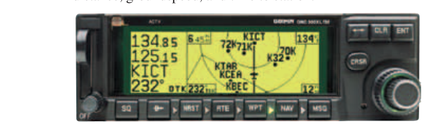
Every IFR clearance routes you through a series of fixes—discrete geographic points that define your path through controlled airspace, mark the start and end of instrument procedures, and anchor holding patterns. On en route low- and high-altitude charts, as well as on Standard Instrument Departures (SIDs), Standard Terminal Arrival Routes (STARs), and instrument approach procedure plates, four fundamental fix types appear repeatedly: VOR stations, NDB stations, RNAV waypoints, and intersections. Each type carries its own symbology, three- to five-letter naming convention, and performance expectation. Mastering the differences is not merely a test-prep exercise—it determines which avionics you'll use, what obstacle clearance guarantees apply, and how you'll brief every segment of an approach in the cockpit.
This article walks through each fix type in depth, explains how controllers and procedures use them, highlights the key regulatory and performance standards, and closes with the traps that appear most often on the FAA Instrument Rating knowledge test.
VOR Fixes
A VOR (Very High Frequency Omnidirectional Range) station is a ground-based navaid that transmits bearing information on a frequency between 108.0 and 117.95 MHz. On IFR en route charts, a VOR is depicted as a compass rose (hexagon-style circle with tick marks) centered on the station symbol. The station name, frequency, Morse-code identifier, and channel number (for TACAN-paired VORTACs) are printed in a box adjacent to the symbol.
VOR fixes are among the most authoritative fix types on IFR charts because the station itself is the fix—you are directly overhead (or on a specific radial from) a physical transmitter whose position is surveyed to high precision. En route airways (Victor airways below 18,000 feet MSL, Jet routes at or above 18,000 feet) are defined as the straight-line path between VORs along specific radials. For example, V23 might be defined as the 090° radial from VOR Alpha to the 270° radial of VOR Bravo. The Minimum En Route Altitude (MEA) and Minimum Obstruction Clearance Altitude (MOCA) printed on the airway segment guarantee obstacle clearance only when you fly that radial within the published airway width (4 nautical miles each side of centerline).
When an approach procedure uses a VOR as the final approach fix or as a stepdown fix, the course deviation indicator (CDI) gives full-scale deflection at ±10° from the selected radial (or ±0.3 NM on RNAV equipment). Understanding that sensitivity difference is critical when flying VOR-based approaches versus RNAV approaches.
NDB Fixes
A Non-Directional Beacon (NDB) transmits in the low/medium frequency range (190–535 kHz). Unlike a VOR, an NDB provides no bearing output from the station; instead, the aircraft's Automatic Direction Finder (ADF) senses the relative bearing to the station and displays it on a relative-bearing indicator or Radio Magnetic Indicator (RMI). On IFR charts, an NDB is shown as a small open circle (often with a dot at center) accompanied by its name, frequency, and two- or three-letter Morse identifier.
NDB fixes are considerably less precise than VOR or RNAV fixes. The ADF needle is susceptible to interference from lightning (thunderstorm static), coastal refraction (signals bending at coastlines), and night effect (sky-wave interference after sunset). The FAA's Instrument Flying Handbook (FAA-H-8083-15) catalogs these error sources carefully. Despite this, NDB approaches remain published at many airports, and Locator Outer Markers (LOM)—low-powered NDBs co-located with outer markers on ILS approaches—still appear on approach plates. If your aircraft is NDB-equipped, you can use the LOM as an approach fix and as a timing reference.
On NDB approach plates, the plan view shows the NDB symbol, the inbound course in magnetic degrees, and the procedure turn or hold-in-lieu-of-procedure-turn area. Because there is no radial output, course guidance requires the pilot to mentally convert relative bearing to magnetic bearing to track inbound—a skill the knowledge test probes with ADF intercept and tracking questions.
RNAV Waypoints
RNAV (Area Navigation) waypoints are computer-defined geographic coordinates expressed in latitude and longitude and stored in an approved navigation database. On charts they appear as a five-pointed star (filled, for fly-over waypoints) or a four-pointed open star or small triangle (fly-by waypoints, depending on chart version and publisher). Names are always five letters for en route or terminal waypoints (e.g., HIFLY, KEELE) and five alphanumeric characters for some approach fixes.
RNAV procedures use GPS (and in some cases VOR/DME or DME/DME position) to define fixes with far greater density than ground-based navaids allow. Because a waypoint exists only in a database—not as a physical transmitter—procedure designers can place fixes precisely where obstacle clearance and airspace geometry demand them, not merely where it is practical to build a ground station.
The accuracy standard for IFR RNAV operations is enshrined in the concept of Required Navigation Performance (RNP). Basic RNAV (RNAV 2 for en route, RNAV 1 for terminal) requires the aircraft to remain within 2 NM or 1 NM of centerline respectively for 95% of flight time. RNAV (GPS) approaches flown to LNAV minima use a 0.3 NM full-scale CDI sensitivity in the final approach segment; LPV (Localizer Performance with Vertical Guidance) approaches tighten that to angular sensitivity similar to an ILS localizer, and the vertical guidance uses SBAS (WAAS) to provide glidepath information. The approach chart will list separate minima lines for LPV, LNAV/VNAV, and LNAV-only, so pilots must know which capability their equipment and database support.
Fly-by vs. fly-over waypoints is a distinction tested on the knowledge exam. A fly-by waypoint is one where the FMS begins the turn to the next course before reaching the fix, using a calculated turn anticipation distance. A fly-over waypoint requires the aircraft to cross directly over the fix before beginning any turn—these appear at holding fixes, missed approach points, and other locations where early turning would violate airspace or obstacle clearance. On charts, a fly-over waypoint is depicted with a circle drawn around the star symbol.
Intersections
Intersections are fixes defined by the crossing of two or more radio bearings, radials, or distance arcs rather than by a single navaid. The name of an intersection is always five letters (e.g., WITCH, BRAND, HOGAN). On en route charts, the intersection symbol is a solid triangle. The chart notation shows which VOR radials, NDB bearings, or DME distances define the fix—for instance, "BRAND intersection: 15 DME on the XYZ VOR 045° radial."
Intersections serve several important IFR functions. They mark the boundaries between airway segments (where MEA or route changes), define mandatory reporting points in non-radar environments, identify holding fixes, and serve as initial approach fixes or intermediate fixes on instrument approaches. Because they are defined by crossing information from two sources, they are slightly less immediate than a VOR overhead but still provide reliable, chart-published positions.
In radar-equipped environments, controllers frequently issue direct-to clearances to intersections ("Cleared direct HOGAN, then as filed"), and the pilot must be able to identify the fix in the FMS database or, for non-RNAV aircraft, set up the appropriate VOR radials and cross-check.
Why It Matters for IFR Operations
Confusing fix types has real consequences. Using a VOR fix as if it were a waypoint you can fly direct to when your aircraft lacks DME or GPS could leave you unable to identify the fix at all. Attempting an NDB approach without a functioning ADF is illegal unless an alternate means of navigation is authorized. Accepting a clearance to a named waypoint your FMS database does not contain means you have no way to navigate to it without ATC radar vectors.
Fix type also governs obstacle clearance guarantees. The protected airspace width, the Minimum Crossing Altitude (MCA), and the missed approach point location are all computed based on the navigation accuracy the fix type implies. Descending below a published altitude before positively identifying the fix—regardless of fix type—removes FAA obstacle protection and can be fatal in IMC.
Key Numbers and Rules
- VOR frequency range: 108.0–117.95 MHz; airways protected 4 NM each side of centerline below 18,000 feet MSL.
- NDB frequency range: 190–535 kHz; ADF required equipment for NDB approaches.
- RNAV waypoint names: exactly five letters (or five alphanumeric characters for some approach fixes).
- Intersection names: exactly five letters; depicted as solid triangles on en route charts.
- RNAV 1 accuracy: within 1 NM of centerline, 95% of flight time (terminal areas).
- RNAV 2 accuracy: within 2 NM of centerline, 95% of flight time (en route).
- VOR CDI sensitivity: full-scale deflection at ±10° (approximately 6 NM each side at 34 NM from station).
- RNAV GPS CDI in final approach: full-scale = ±0.3 NM (LNAV); LPV uses angular sensitivity comparable to ILS localizer.
- Fly-over waypoint: circle drawn around the star symbol; aircraft must cross the fix before turning.
Common Test Traps
- Five-letter name = RNAV waypoint, not intersection? Both RNAV waypoints and intersections use five-letter names. The chart symbol distinguishes them: star or triangle for waypoints, solid triangle for intersections. Look at the symbol, not just the name length.
- NDB bearing vs. VOR radial confusion: An NDB transmits undirected signals; bearings TO an NDB are magnetic bearings the ADF reads. A VOR radial is a specific direction FROM the station. Test questions often swap these, so be precise about the direction.
- MEA guarantees signal reception, MOCA does not (always): The MOCA guarantees obstacle clearance but only guarantees VOR signal reception within 22 NM of the VOR. Below the MEA but above the MOCA, you may lose navaid signal farther from the station.
- Fly-by vs. fly-over: Many students assume all waypoints are fly-by. Missed approach waypoints and holding fixes are typically fly-over; beginning a turn early violates the procedure and potentially airspace constraints.
- RNAV approach minima lines: The chart may list LPV, LNAV/VNAV, and LNAV minima. Using LPV minima requires WAAS-certified equipment AND an LPV glidepath signal; LNAV/VNAV requires baro-VNAV or WAAS but uses different temperature limits. Never use a lower minima line than your equipment certification supports.