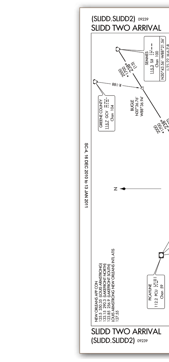
When you are flying IFR and nearing your destination, air traffic control (ATC) does not want to issue a long string of individual radar vectors and altitude assignments for every arrival aircraft. Instead, the FAA publishes Standard Terminal Arrival Routes (STARs) — pre-planned, charted procedures that smoothly funnel traffic from the en route airway structure down into the terminal area where an approach can begin. For instrument-rated pilots, fluency in reading STAR charts is not optional; it is a fundamental skill that keeps you ahead of the airplane, minimizes miscommunication with ATC, and ensures compliance with both published altitudes and speed restrictions.
STARs are contained in the FAA Terminal Procedures Publication (TPP), the same bound booklets (or electronic equivalents) that hold approach charts and departure procedures. Each STAR chart looks complex at first glance, but once you understand its components, it becomes a clear graphical roadmap from the high-altitude structure all the way to the initial approach fix (IAF) or the beginning of a specific approach procedure.
Anatomy of a STAR Chart
Every STAR chart is divided into a plan view (the overhead map of the route) and a text/profile section at the top or bottom of the chart. Understanding what lives in each area is the first step to reading them fluently.
The Header Block
The top of the chart contains the procedure name, the issuing authority (FAA), the city and airport served, and the chart amendment date. The procedure name tells you the fix or navaid that anchors the procedure and, often, a number to distinguish it from earlier versions (for example, "ZZIPT TWO ARRIVAL"). When ATC issues a STAR clearance, they use this name exactly, so you must match it precisely to the chart in hand.
Plan View
The plan view shows the geographic layout of the route. Key elements include:
- Fixes and navaids: Named waypoints (shown as a circled triangle for fly-over fixes or a plain flag-like symbol for fly-by waypoints), VORs (hexagons), and GPS/RNAV waypoints. Each fix is labeled with its name, and the transition fixes that feed into the common route are usually shown in different colors or line weights.
- Route segments: Bold lines connect fixes along the arrival. Where multiple transitions converge onto a single "common route," the lines merge at a specific fix — think of tributaries flowing into a river.
- Magnetic courses: Each route segment is annotated with its magnetic course (e.g., "174°") and, where published, the distance in nautical miles between fixes.
- Altitudes: Altitude restrictions appear directly on the plan view beside the associated fix. A number underlined means at or above; a number with a line over the top means at or below; a number with lines both above and below (or shown as two numbers) means at that exact altitude, or between the two altitudes. Mandatory altitudes (a bold box around the number) must be crossed at that altitude — no exceptions without an ATC amendment.
- Speed restrictions: Published as a knot value in parentheses or with a "KT" annotation beside a fix. Like altitude restrictions, these are mandatory unless ATC explicitly cancels them with a phrase such as "delete speed restrictions."
- Minimum en route altitudes (MEAs) and minimum obstruction clearance altitudes (MOCAs): Where applicable, segment minimum altitudes appear along the route for terrain and obstruction clearance reference.
Transition Routes vs. the Common Route
Most STARs include two structural layers. Transitions are the initial segments that bring aircraft from various en route entry points (different VORs, waypoints, or airways) to a common merge point. The common route then carries all of that merged traffic from that merge fix down to the terminal area or the approach IAF. When ATC clears you for a STAR, they typically specify both the transition name and the STAR name, for example: "Cleared the PARCH transition, ZZIPT TWO arrival." If they omit the transition, confirm with ATC which entry point applies to your route.
The Textual Route Description
At the top of most STAR charts is a written description of the route, fix by fix, with altitudes and speeds. This text is especially useful for programming a flight management system (FMS) or GPS navigator, because it presents every waypoint in order with precise crossing restrictions. Cross-check your FMS route against this text before departure and again during the arrival to confirm the correct sequence of fixes and that all altitude and speed constraints have been entered correctly.
How Altitude and Speed Restrictions Work in Practice
The altitude and speed restrictions on a STAR are mandatory the moment you accept the clearance — unless ATC explicitly modifies them verbally. This is a critical distinction from the en route environment. If a fix shows "FL190" with a mandatory restriction box, you must cross that fix at FL190. If you are at FL240 and the fix is 30 miles away, the math of descent planning is on you.
A useful mental model: treat each mandatory fix on a STAR like a gate you must fly through. If you arrive at that gate too high, you cannot simply level off and cross it 5,000 feet above; that violates your clearance and compromises separation. Use your vertical navigation (VNAV) capability, the 3:1 rule of thumb (three nautical miles of distance for each 1,000 feet of descent, plus a buffer for deceleration), and the chart's profile view to verify your descent planning well in advance.
Speed restrictions are equally binding. A published "250 KT" restriction at a fix means you must cross that fix at or below 250 knots. Note that the regulatory 14 CFR §91.117 speed limit of 250 KIAS below 10,000 feet MSL always applies as an independent regulatory floor, regardless of what a STAR publishes.
RNAV STARs and the Role of the FMS
Modern STARs are increasingly RNAV-based, meaning they rely on GPS/GNSS or FMS area navigation rather than ground-based navaids. RNAV STARs use RNAV waypoints (five-letter names) and may incorporate radius-to-fix (RF) legs — constant-radius turns between two waypoints — that are flyable only with a certified FMS. If your aircraft is not equipped to fly RF legs, you cannot accept an RNAV STAR that contains them without ATC approval for an alternative routing.
When loading an RNAV STAR into your FMS, verify that every waypoint sequence matches the chart exactly. Pay particular attention to the transition entry point you were assigned. FMS databases occasionally have naming differences between chart editions; always use the chart as the authoritative reference and confirm that the FMS-generated routing matches it graphically before you commit to the procedure.
Why STARs Matter: Safety and Efficiency
STARs exist because busy terminal areas handle dozens or hundreds of arrivals per hour. Without standardized procedures, ATC would spend enormous time and radio frequency bandwidth issuing individual routing instructions. By accepting a STAR, you and ATC share a common picture of where you are going and at what altitudes. This shared situational awareness reduces the potential for altitude busts, traffic conflicts, and runway incursions that can stem from misunderstood routing instructions.
For the instrument pilot, STARs also reduce cognitive load during one of the most demanding phases of flight — the descent and transition to an approach. When the route, altitudes, and speeds are pre-planned and charted, you can devote more mental bandwidth to weather, aircraft configuration, and communication.
Key Numbers and Rules
- Mandatory altitude restriction: A fix altitude shown in a bold box must be crossed exactly at that altitude unless ATC amends the restriction.
- At or above: Underline beneath the altitude number.
- At or below: Overline (line above) the altitude number.
- Between two altitudes: Both numbers shown, representing the acceptable window (e.g., "8,000" over "6,000" means cross between 6,000 and 8,000 feet).
- Speed restrictions: Mandatory unless ATC deletes them; always superseded by the 250 KIAS/10,000-foot regulatory limit if that limit is more restrictive.
- RNAV RF legs: Require a certified FMS; not flyable with basic GPS or raw-data navigation.
- Chart currency: STARs are updated on the 56-day AIRAC cycle; always use current charts.
Common Test Traps
- Ignoring the transition vs. common route distinction: The FAA knowledge test may present a STAR scenario where you must identify whether a specific restriction applies to the transition segment or the common route. Read the chart carefully — restrictions on transition fixes apply only when flying that transition.
- Misreading altitude symbols: Confusing "at or above" (underline) with "at or below" (overline) is one of the most common errors. On the test and in the cockpit, double-check which constraint type is shown at each fix.
- Assuming all altitude restrictions are optional: Some candidates mistakenly believe STAR restrictions are advisory. They are mandatory upon accepting the clearance. ATC must explicitly amend them for you to deviate.
- Forgetting that a STAR does not include the approach: A STAR ends at a fix in the terminal area, not at the runway. You still need a separate approach clearance and must transition to the correct approach chart at the appropriate fix.
- Loading the wrong transition in the FMS: If ATC clears you via "ALPHA transition" and you load "BRAVO transition" in your FMS, you will fly an unauthorized route. Always verify the loaded transition against both your clearance and the chart before the fix is reached.