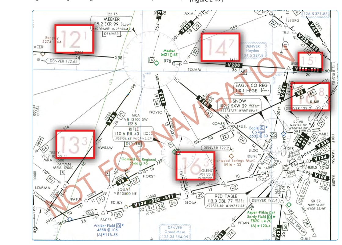
When flying IFR, pilots spend most of their attention on airways, MEAs, and published procedures — but what happens when you venture off an established route, or when you need a quick reference for terrain and obstacle clearance in areas not covered by a specific airway? That's exactly the problem the Off-Route Obstruction Clearance Altitude (OROCA) was designed to solve. Printed in large blue numerals on IFR en route low-altitude and high-altitude charts, OROCA values give pilots a fast, conservative answer to the question: "How high must I be right here to clear everything beneath me?"
Understanding OROCA is essential both for the Instrument Rating knowledge test and for practical cross-country IFR flying. It is one of several "minimum safe altitude" values you'll encounter on IFR charts, each with distinct guarantees and limitations — and the FAA loves to test whether pilots know the difference.
What OROCA Is and How It Is Computed
OROCA is defined as an altitude that provides obstruction clearance within a specific geographic grid square on an IFR en route chart, with a 1,000-foot buffer above the highest obstacle in non-mountainous areas and a 2,000-foot buffer in designated mountainous areas. The values are computed on a one-degree latitude by one-degree longitude grid — each grid square is roughly 60 nautical miles wide at mid-latitudes — and the single printed value covers the entire square.
The computation process begins with the chart compilers identifying the highest known obstacle within a given grid square, which could be a mountain peak, a broadcast tower, a tall building, or any other charted obstruction. They then add the appropriate buffer (1,000 ft or 2,000 ft) and round up to the nearest 100 feet. The result is printed on the chart. This rounding-up philosophy is intentionally conservative: if the math yields 7,850 feet, the published OROCA is 8,000 feet.
OROCA values appear in blue on IFR en route low-altitude charts (and similarly on high-altitude charts), distinguishing them from the magenta Maximum Elevation Figure (MEF) values found on VFR sectional charts. The format uses thousands and hundreds — for example, "72" means 7,200 feet MSL, while "135" means 13,500 feet MSL.
What OROCA Does — and Does NOT — Guarantee
This is the most critical distinction for both the knowledge test and real-world operations. OROCA provides obstruction clearance only. It carries three important limitations that pilots must memorize:
- No navigation signal guarantee. Flying at or above OROCA does not ensure you will receive usable VOR, NDB, or other ground-based navigation signals. Terrain may block line-of-sight to ground stations, and the OROCA computation makes no allowance for this.
- No ATC communication guarantee. OROCA does not guarantee that you will be in radar contact with ATC or that voice communication will be possible. Again, terrain masking can prevent both radar returns and radio reception at lower altitudes.
- No IFR routing guarantee. OROCA is not an IFR route. It does not authorize flight in controlled or special-use airspace, nor does it imply ATC separation services.
Compare this to the Minimum En Route Altitude (MEA), which guarantees obstacle clearance and navigation signal reception along a specific airway segment. Or the Minimum Reception Altitude (MRA), which is the lowest altitude at which an off-airway fix can be reliably received. OROCA intentionally makes no such communication or navigation promises — its sole purpose is terrain and obstacle clearance in airspace that may have no published airway at all.
Where and When OROCA Applies
OROCA is specifically designed for off-route operations — those times when a pilot is not tracking a published airway or procedure. Common scenarios include:
- Direct GPS routing between waypoints that takes the aircraft away from any established airway.
- Lost communications procedures where you are continuing toward your destination via a direct path.
- Diversion or rerouting situations where ATC issues a vector or direct clearance into airspace with no published MEA.
- Preflight planning to assess terrain exposure along a proposed off-airway direct route.
Even in the modern GPS era, where direct routing is commonplace and pilots often fly point-to-point rather than airway-to-airway, OROCA remains a valuable cross-check. If ATC clears you "direct" to a fix and the routing takes you across a mountain range, the OROCA printed for those grid squares gives you an immediate terrain-clearance reference while you assess your assigned altitude.
OROCA vs. Other Minimum Altitudes: Knowing the Difference
The IFR environment is populated with a family of minimum altitude values, and the FAA knowledge test frequently presents scenarios designed to see if pilots understand each one's specific guarantee. A focused comparison:
- MEA (Minimum En Route Altitude): Guarantees obstacle clearance and navigation signal reception along a published airway segment. This is route-specific.
- MOCA (Minimum Obstruction Clearance Altitude): Guarantees obstacle clearance along an airway, but guarantees acceptable navigation signal coverage only within 22 NM of the VOR defining that route. It is always equal to or lower than the MEA and appears on charts preceded by an asterisk (*).
- MRA (Minimum Reception Altitude): The lowest altitude at which a specific off-airway intersection or fix can be reliably received from the defining navigation facilities.
- MSA (Minimum Safe Altitude): Published on approach charts within a 25 NM radius of a specified fix, providing 1,000 ft obstacle clearance. Emergency use only — it does not guarantee navigation signal or radar coverage.
- OROCA: Off-route, grid-based, 1,000/2,000 ft obstruction clearance only — no nav, no comms guarantee.
- MEF (Maximum Elevation Figure): Found on VFR sectionals and WAC charts, not IFR charts. Similar grid concept, but the buffer differs — 328 feet above the highest natural terrain or vegetation, or 656 feet above man-made obstacles under 1,000 feet AGL, rounded up to the next 100-foot increment — and it is a VFR tool.
Key Numbers and Rules
- Obstruction clearance buffer: 1,000 feet in non-mountainous areas, 2,000 feet in designated mountainous terrain (same buffers as used for MEA computation).
- Grid size: 1° latitude × 1° longitude per value.
- Chart color: blue on IFR en route charts.
- Guarantees: obstruction clearance ONLY — no navigation signal, no ATC communications, no radar coverage.
- Values round up to the nearest 100 feet.
- OROCA is valid for the entire grid square, regardless of where within the square you are flying.
- Mountainous area designations are found in 14 CFR Part 95, which also governs MEAs for airways.
Practical Application in the Cockpit
During preflight planning for an IFR flight with significant direct-routing segments, check the OROCA values for every grid square your route traverses. Compare these values to your proposed cruising altitude. If your planned altitude is below the OROCA for any square, you either need to increase your altitude or find an airway route with a published, lower MEA that is safe for that terrain.
In-flight, if you receive an unexpected direct clearance, quickly scan the OROCA values on your en route chart for the squares you'll cross. Modern EFB applications display OROCA values and can alert you if your altitude is below OROCA for your current position. This is especially important at night or in IMC when visual terrain avoidance is impossible.
Keep in mind that OROCA is a planning and awareness tool, not a substitute for ATC clearances or published procedures. You should always be flying at an altitude that has been cleared by ATC during IFR operations unless you are in an emergency or lost communications situation — in which case 14 CFR 91.185 governs your altitude choices, and OROCA serves as a valuable cross-check.
Common Test Traps
- Confusing OROCA with MEA. The FAA frequently tests whether students know that OROCA does NOT guarantee navigation signal reception. MEA does; OROCA does not. If a question asks which altitude guarantees both obstruction clearance and nav signal, the answer is MEA, never OROCA.
- Assuming OROCA guarantees radar contact or radio communication. It guarantees neither. MSA on an approach chart and OROCA on an en route chart both share this limitation.
- Mixing up OROCA and MEF. MEF is on VFR sectionals (magenta); OROCA is on IFR charts (blue). They use different buffer values and serve different audiences. Don't confuse the two in a question about IFR en route charts.
- Forgetting the mountainous area exception. The 1,000/2,000 ft buffer difference matters. A question may describe a grid square in a designated mountainous area and ask about the obstruction clearance provided — the correct answer is 2,000 feet, not 1,000.
- Treating OROCA as an IFR routing authorization. OROCA is a clearance reference, not a clearance. You must still have an ATC clearance to fly in controlled airspace, and OROCA does not grant any routing authority on its own.