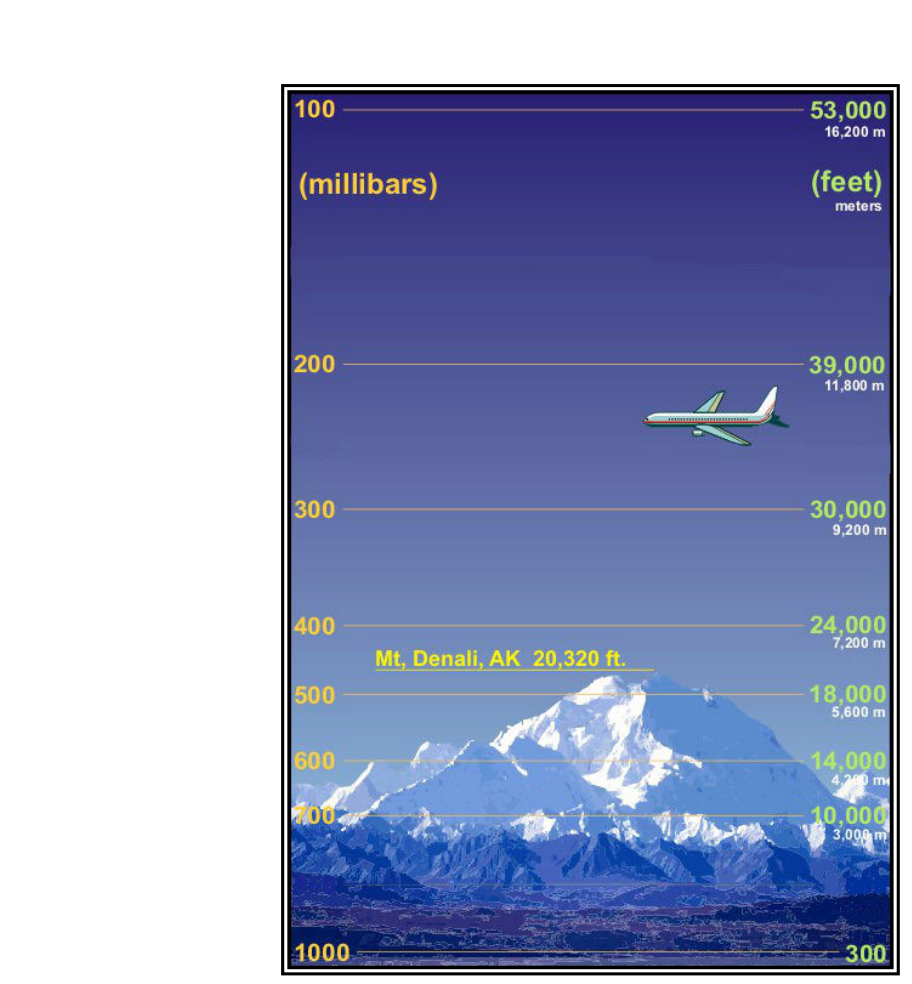
Every time you set your altimeter, calculate density altitude, or read a performance chart in your Pilot's Operating Handbook, you are relying on a carefully defined mathematical model called the International Standard Atmosphere (ISA). This model gives aviation a common reference — a hypothetical "average" atmosphere against which real-world conditions can be compared. Without it, altimeters would be uncalibrated guesses, and aircraft performance data would be meaningless. Understanding how the standard atmosphere is built, and how pressure, temperature, and density change with altitude, is both an FAA knowledge test staple and a genuine foundation of flight safety.
The concepts covered here connect directly to density altitude, true altitude, altimeter errors, and aircraft performance — all topics that appear repeatedly on the Private Pilot written exam and that matter every single flight you make.
What the Standard Atmosphere Actually Is
The standard atmosphere is a mathematical model adopted internationally. It defines a specific set of sea-level conditions and a predictable rate at which temperature (and therefore pressure and density) change as altitude increases. It does not describe what the atmosphere actually is on any given day — it is a baseline for comparison. When conditions differ from standard, pilots must account for those differences in their planning.
The FAA's Pilot's Handbook of Aeronautical Knowledge specifies the following standard sea-level conditions:
- Temperature: 59°F (15°C)
- Pressure: 29.92 inches of mercury (inHg), which equals 1013.2 millibars (mb) or hectopascals (hPa)
- Density: 0.002377 slugs per cubic foot (the baseline against which density altitude is measured)
- Lapse rate (temperature): approximately 2°C (3.5°F) decrease per 1,000 feet of altitude gain up through the tropopause
These values form the backbone of every altimeter, every performance chart, and every density altitude formula used in general aviation.
How Pressure Changes with Altitude
Atmospheric pressure is simply the weight of all the air above a given point pressing down. At sea level, that column of air exerts about 14.7 pounds per square inch (psi) — expressed in aviation as 29.92 inHg. As you climb, there is less air above you, so the pressure decreases.
The pressure decrease is not perfectly linear — it is actually exponential, meaning pressure drops relatively quickly at lower altitudes and more slowly at extreme heights. For practical purposes in the lower atmosphere, however, pilots use the following useful approximation: pressure decreases approximately 1 inHg for every 1,000-foot increase in altitude near sea level. This rule of thumb is especially handy when checking altimeter settings between airports.
This relationship is exactly what makes altimeters work. An altimeter is essentially a sensitive aneroid barometer. It measures the ambient static pressure and, using the known pressure-altitude relationship from the standard atmosphere, converts that pressure into an indicated altitude. When you dial in the local altimeter setting (called the Kollsman window setting), you are correcting for the actual sea-level pressure at your location so the instrument reads your true height above mean sea level (MSL) — as long as temperature is standard.
How Temperature Changes with Altitude
The standard lapse rate — the rate at which temperature drops as you climb — is approximately 2°C per 1,000 feet (3.5°F per 1,000 feet) in the troposphere. The troposphere is the lowest layer of the atmosphere, extending to roughly 36,000 feet in the standard model. At that level, called the tropopause, temperature stops falling and levels off at approximately −56.5°C (−69.7°F). Above the tropopause is the stratosphere, where temperature remains essentially constant and then begins to rise again — but private pilot operations almost never reach those altitudes.
On any given day, the actual lapse rate in the real atmosphere can be higher (called a superadiabatic lapse rate, associated with unstable air and convective activity) or lower (stable air, possibly an inversion where temperature increases with altitude). These deviations from standard have enormous consequences for weather, turbulence, and aircraft performance.
Density and Why It Matters Most to Pilots
Air density is the mass of air molecules per unit of volume. Density ties directly to pressure and temperature through basic physics: higher pressure increases density; higher temperature decreases density. Since both pressure and temperature change with altitude, so does density.
In the standard atmosphere, density decreases continuously as altitude increases. At 18,000 feet MSL, air density is roughly half of what it is at sea level. This matters enormously to pilots because aircraft performance — lift, thrust, and engine power — all depend on air density. An engine that produces 100% power at sea level produces significantly less at 10,000 feet because the thinner air contains fewer oxygen molecules per cubic foot.
This is the heart of the density altitude concept. Density altitude is the altitude in the standard atmosphere that corresponds to the actual density of the air at your location. If the air is hotter or more humid than standard, density altitude is higher than pressure altitude, and your aircraft performs as if it were at a greater elevation than it actually is. On a hot summer day at a high-elevation airport, density altitude can easily exceed field elevation by 3,000 to 5,000 feet — with potentially disastrous effects on takeoff performance if not accounted for.
The Four Altitudes Every Pilot Must Know
The standard atmosphere framework produces four distinct altitude definitions that the FAA tests consistently:
- Indicated Altitude: What your altimeter reads with the current altimeter setting (Kollsman window) dialed in. This is the value used for ATC separation and VFR cruising altitudes.
- Pressure Altitude: The altitude corresponding to a given pressure in the standard atmosphere, found by setting 29.92 inHg in the Kollsman window. Used for performance calculations and above FL180 where all aircraft use 29.92.
- Density Altitude: Pressure altitude corrected for non-standard temperature (and sometimes humidity). This is the true performance altitude — the number that determines what your aircraft can actually do.
- True Altitude: Your actual height above mean sea level. Indicated altitude equals true altitude only when the altimeter setting is accurate and temperatures are standard. In cold air (denser, lower than standard), the altimeter over-reads — you are actually lower than indicated. This is the basis of the aviation saying "High to low, look out below."
Why It Matters: Real-World and Safety Applications
Understanding the standard atmosphere is not academic exercise — it directly affects go/no-go decisions. Performance charts in your POH are based on standard atmosphere conditions. If your density altitude is significantly above standard, takeoff roll lengthens, climb rate decreases, and engine power diminishes. Pilots who do not account for these differences have run out of runway and failed to clear obstacles on hot, high-elevation days.
Cold temperatures create a different hazard: altimeter over-reading. When flying in temperatures significantly below standard, true altitude is lower than indicated altitude. This matters critically during instrument approaches and obstacle clearance — the FAA provides cold temperature correction tables in the AIM precisely because the standard atmosphere assumption embedded in the altimeter becomes dangerously optimistic in very cold air.
Altimeter settings also reinforce this understanding. When flying from a high-pressure area into a low-pressure area without updating your altimeter setting, the instrument will read too high while you are actually lower than you think — hence the mnemonic below.
Memory Aid
"High to low, look out below — hot to cold, same story told."
- High to low (pressure): Flying from a high-pressure area to a low-pressure area without correcting your altimeter makes you think you are higher than you are. You are actually closer to terrain.
- Hot to cold: Flying from warm air into cold air, the altimeter over-reads. Your true altitude is lower than indicated. The denser cold air compresses the pressure levels together, so a given pressure is found at a lower true height than the standard model assumes.
Common Test Traps
- Confusing pressure altitude with density altitude: Pressure altitude is set by dialing 29.92 in the Kollsman window. Density altitude adds the temperature correction. On a standard-temperature day they are equal; otherwise they are not.
- Assuming warmer temperatures raise your true altitude: Warmer-than-standard temperatures make the altimeter under-read — you are actually higher than indicated. The test often asks which direction the error goes; remember that cold air is the dangerous case where you are lower than you think.
- Forgetting the standard lapse rate value: The FAA tests 2°C per 1,000 feet frequently. Do not confuse this with the dry adiabatic lapse rate (3°C/1,000 ft) used in stability calculations.
- Thinking pressure altitude equals field elevation: Pressure altitude equals field elevation only when the actual sea-level pressure is exactly 29.92 inHg. On most days it is not, so pressure altitude and field elevation differ.
- Overlooking humidity in density altitude: The FAA acknowledges that high humidity reduces air density (water vapor is lighter than the nitrogen and oxygen it displaces), but most POH density altitude charts do not include a humidity correction. On extremely humid days, actual performance may be slightly worse than even the density altitude chart suggests.
Mastering the standard atmosphere gives you the mental framework to understand why your aircraft performs the way it does on any given day, why your altimeter needs a current setting, and why a hot summer afternoon at a mountain airport demands extra caution. It is one of those foundational concepts that quietly underpins almost everything else in aviation — and the FAA knows it, which is why it appears on the knowledge test in multiple forms.