Weather systems are rarely simple, but occluded fronts rank among the most complex phenomena a pilot will encounter. They form late in the life cycle of a mid-latitude storm system, when a rapidly advancing cold front catches up to and merges with the slower-moving warm front that preceded it. The result is a multi-layered atmospheric collision that can produce a wide variety of hazardous conditions — clouds at multiple levels, prolonged precipitation, embedded thunderstorms, and reduced visibility — all compressed into a zone that can be difficult to forecast and even harder to escape once inside it. Understanding how occluded fronts form, what they look like on a weather chart, and what to expect when flying near them is essential knowledge for every certificated pilot.
This article covers the formation mechanics, the two distinct types of occlusion, associated weather hazards, how to identify an occluded front on a surface analysis chart, and the practical cockpit decisions this knowledge demands.
How Occluded Fronts Form
A classic mid-latitude cyclone begins with a wave disturbance along a stationary front, which develops into a counter-clockwise circulation (in the Northern Hemisphere) as it matures, organizing distinct warm and cold air masses. The cold front — the leading edge of the advancing cold air — nearly always moves faster than the warm front ahead of it. As time passes, the cold front closes the gap and eventually overtakes the warm front. At that point, the warm sector of air that once lay at the surface between the two fronts is squeezed aloft. The front that results from this merger at the surface is called an occluded front, and the process is called occlusion.
Think of it as a pincer movement: the warm air mass is literally lifted off the ground and rides upward along the frontal boundary. The surface weather station that was once in the warm sector now finds itself under a thick, multi-layered cloud system with the warm air mass existing only at altitude above the frontal zone.
The Two Types of Occlusion
The structure of an occluded front depends on the temperature relationship between the two cold air masses involved — the original cold air behind the cold front and the cool air ahead of the warm front.
Cold-Type Occlusion
In a cold-type occlusion, the air behind the overtaking cold front is colder than the cool air ahead of the warm front. Because it is denser, the advancing cold air undercuts both the warm air and the cool air ahead of the warm front, forcing everything upward. The cold-type occlusion essentially resembles a cold front at the surface and is the more common type over North America. It tends to produce the sharper pressure changes, more vigorous lifting, and potentially stronger convective activity associated with cold fronts.
Warm-Type Occlusion
In a warm-type occlusion, the air behind the cold front is actually less cold than the cool air ahead of the warm front. In this scenario, the advancing air rides up over the cooler air mass, so the surface characteristics more closely resemble a warm front. Weather associated with the warm-type occlusion tends to spread over a broader area with lower ceilings, extensive stratiform clouds, and prolonged steady precipitation — characteristics that make it particularly deceptive and instrument-flight-challenging.
Weather Associated with Occluded Fronts
Occluded fronts combine the worst characteristics of both cold and warm fronts into a single, often prolonged weather event. Pilots planning flights through or near an occluded front should anticipate all of the following:
- Extensive cloud coverage: Because the warm air has been lifted to altitude, clouds often develop at multiple levels simultaneously. Expect cirrus and cirrostratus high above, altostratus and altocumulus in the middle levels, and stratus or nimbostratus near the surface — sometimes all at once.
- Prolonged precipitation: The slow movement of an occluded system and the depth of available moisture typically produce hours of continuous or intermittent precipitation, including rain, freezing rain, sleet, or snow depending on surface temperatures.
- Structural icing: With warm moist air lifted above the freezing level and cold air below, the zone of an occluded front is prime territory for structural icing in clouds and precipitation. Freezing rain — supercooled large droplets falling through subfreezing surface air — is especially dangerous and can accumulate rapidly on airframe surfaces.
- Embedded thunderstorms: Particularly in the cold-type occlusion, convective activity from the original cold front can persist and become embedded within the general overcast, making thunderstorm avoidance extremely difficult because the visual cues used in VFR flight (cumulonimbus tops, dark anvils) are hidden inside layered cloud decks.
- Reduced visibility: Low ceilings, fog, drizzle, and precipitation all combine to reduce visibility, sometimes well below VFR minimums over large geographic areas.
- Turbulence: Wind shear between the different air masses at varying levels creates turbulence that can range from light chop to severe, particularly in the vicinity of the frontal boundary itself.
Identifying an Occluded Front on a Weather Chart
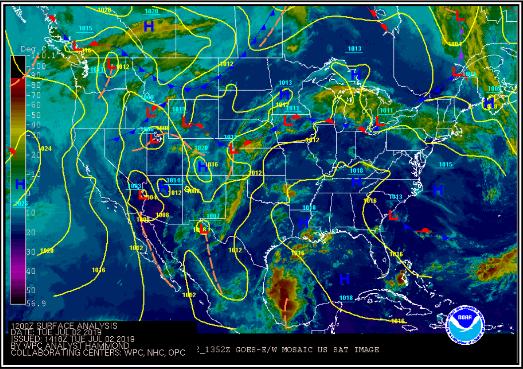
On a standard surface analysis chart, an occluded front is depicted as a purple line (or alternating blue triangles and red semicircles on the same side of the line). This symbolism reflects the mixed nature of the system — combining the triangular cold-front symbol and the semicircular warm-front symbol into one. The alternating pips point in the direction the front is moving.
The surface low-pressure center is always located at the end of the occluded front where the warm and cold fronts originally met. As the storm system matures, the occluded portion of the front grows longer, and the warm sector at the surface shrinks or disappears entirely. A long occluded front on a weather chart generally indicates an aging, weakening storm system — but one that still carries significant weather hazards, particularly aloft.
Pilots reviewing a prog chart or surface analysis should trace the occluded front's position relative to their route and check the associated winds and temperatures aloft forecasts (FB), AIRMETs, and SIGMETs for an accurate picture of where icing, turbulence, and IFR conditions are most concentrated.
Key Numbers and Rules
- Frontal speed: Cold fronts generally move faster than warm fronts, which is why cold fronts eventually overtake warm fronts and cause occlusion; the Aviation Weather Handbook does not specify precise universal speed thresholds, as actual frontal speed varies considerably with the pressure gradient and upper-level flow.
- Weather width: Occluded fronts can produce significant weather spread over a broad area, generally wider than the weather zone associated with a cold front alone, though the Aviation Weather Handbook does not give a fixed mileage figure for either.
- Icing altitude: Structural icing in an active occluded system exists wherever visible moisture and temperatures between roughly 0°C and -20°C coexist, which can range from near the surface well into the higher flight levels; always check pireps (PIREPs) for actual icing reports rather than relying on a fixed altitude ceiling.
- AIRMET Sierra: Widespread IFR conditions — ceilings below 1,000 feet and/or visibility below 3 miles affecting 50 percent or more of the forecast area — are common in occluded frontal areas and will typically generate an AIRMET Sierra for IFR conditions.
- AIRMET Zulu: Moderate icing in clouds and precipitation associated with occluded fronts will normally be covered by an AIRMET Zulu (icing) advisory.
- SIGMET: Severe or extreme turbulence and severe icing warrant SIGMETs; embedded thunderstorms also generate Convective SIGMETs. Never penetrate a Convective SIGMET area without proper equipment, training, and a strong reason.
Why It Matters for Pilots
The FAA's Aviation Weather Handbook is explicit: frontal weather — and occluded frontal weather in particular — is responsible for a disproportionate share of weather-related accidents. The hazard is compounded by the fact that the occlusion process hides and blends weather that would otherwise be identifiable and avoidable. A pilot who can see a towering cumulonimbus can fly around it; a pilot who encounters embedded convection inside a gray overcast may have no warning until severe turbulence or a lightning strike provides a very unwelcome surprise.
The wide geographic spread of occluded-front weather means that scud running or trying to stay VFR beneath a frontal system is rarely a viable option. The ceiling drops gradually, the visibility deteriorates, and the terrain clearance that seemed adequate 30 miles back may no longer exist. This is the classic scenario that leads pilots into inadvertent IMC — a situation with a poor statistical outcome for those without an instrument rating and proficiency.
For student pilots and newly certificated private pilots, the most important takeaway is this: when a weather briefer describes an occluded front along or near your route, treat the entire system with deep respect. Obtain a thorough preflight weather briefing that includes the standard weather briefing from a Flight Service specialist, review AIRMETs and SIGMETs, check pilot reports (PIREPs) for actual conditions, and build in an honest go/no-go decision process before you depart.
Common Test Traps
- Confusing occlusion types: The FAA knowledge test may ask which type of occlusion produces cold-front-like versus warm-front-like weather at the surface. Remember: cold-type occlusion = colder air behind the front undercuts everything (sharp cold-front weather); warm-type occlusion = less-cold air behind rides over cooler air ahead (broad warm-front weather).
- Chart symbology: Students sometimes confuse a stationary front (alternating red and blue on opposite sides) with an occluded front (purple, or red semicircles and blue triangles on the same side). Know the difference.
- Thinking it's a dying system: A long occluded front may look like a weakening storm on a chart, and it is — at the surface. But aloft, the lifted warm air mass can sustain hazardous conditions including icing and embedded convection long after the surface features appear benign.
- Underestimating geographic extent: Test questions may probe whether students understand that occluded frontal weather covers a much wider area than a cold front alone. Don't assume you can quickly fly through it.
- Forgetting about icing: Students sometimes focus on visibility and turbulence and forget that the multi-layered cloud structure of an occluded front is ideal for structural icing, especially at the warm-type occlusion where stratiform clouds dominate and supercooled droplets are abundant.