Every cloud you see in the sky began as invisible water vapor that reached a critical temperature threshold and changed state into liquid droplets or ice crystals. For pilots, understanding exactly how and why that happens is not just academic trivia — it is a practical skill that helps you predict fog on a morning departure, anticipate in-flight icing, and recognize when a clear sky might turn instrument-meteorological-conditions (IMC) in a matter of minutes. The two concepts at the heart of cloud formation are dewpoint and relative humidity, and once you understand how they interact, aviation weather products start telling a much richer story.
This article walks through the physics of water vapor in plain language, explains how pilots use dewpoint and relative humidity operationally, and highlights the numbers and traps the FAA knowledge test loves to probe.
Water Vapor and the Atmosphere
Air is a mixture of gases, and one of those gases is water vapor — water in its invisible, gaseous form. Unlike liquid water or ice, water vapor exerts its own partial pressure within the atmosphere. The critical fact is that air has a limited capacity to hold water vapor, and that capacity depends almost entirely on temperature. Warm air can hold significantly more water vapor than cold air. This relationship is not linear; as temperature rises, the atmosphere's capacity to hold moisture increases rapidly.
When air holds all the water vapor it possibly can at a given temperature, it is said to be saturated. If you add more water vapor to saturated air, or if you cool the air below the temperature at which saturation occurs, water vapor begins to condense — converting from gas to tiny liquid droplets suspended in the air. Those suspended droplets are what we see as a cloud, fog, or mist.
What Is Dewpoint?
The dewpoint temperature (often simply called the dewpoint) is the temperature to which a parcel of air must be cooled, at constant pressure and constant moisture content, for saturation to occur. Put another way, it is the temperature at which condensation begins. The dewpoint is always equal to or lower than the actual air temperature (called the dry-bulb temperature or simply the temperature). The only time dewpoint equals temperature is when the air is already fully saturated — relative humidity is 100%.
Dewpoint is reported in degrees Celsius on aviation weather products such as METARs and surface analysis charts. For example, a METAR might read T 22 / DP 18, meaning the temperature is 22°C and the dewpoint is 18°C. That 4°C spread (called the temperature-dewpoint spread) tells you how close the air is to saturation. A small spread — say 2°C or less — indicates the air is nearly saturated, and you should expect clouds, fog, or precipitation near the surface. A large spread — say 20°C — means the air is far from saturation and cloud formation near the surface is unlikely.
What Is Relative Humidity?
Relative humidity (RH) is the ratio of the amount of water vapor actually in the air compared to the maximum amount the air could hold at that same temperature, expressed as a percentage. When relative humidity reaches 100%, the air is saturated and condensation begins (assuming condensation nuclei are present — see below). When relative humidity is 50%, the air holds half the moisture it could potentially hold at that temperature.
A key insight often missed by students: relative humidity can change even when no moisture is added or removed from the air. Because the atmosphere's holding capacity changes with temperature, cooling air raises relative humidity and warming air lowers it, even with the same absolute amount of water vapor. This is why relative humidity is typically highest just before dawn (when temperatures are at their overnight minimum) and lowest in the early afternoon (when temperatures peak). Fog is most likely at night and in the early morning for exactly this reason.
The Temperature-Dewpoint Spread and Cloud Bases
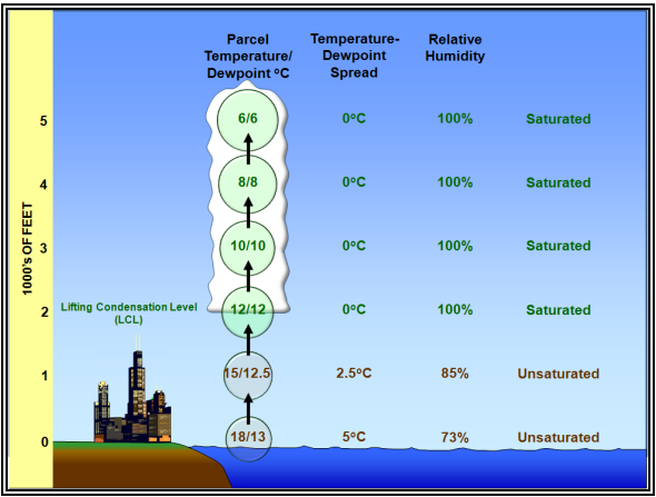
One of the most useful practical applications of these concepts is estimating cloud base height. When air near the surface is lifted — by terrain, a frontal boundary, or surface heating — it cools at the dry adiabatic lapse rate of approximately 3°C per 1,000 feet. Meanwhile, the dewpoint of a rising parcel decreases more slowly, at roughly 0.5°C per 1,000 feet. Because temperature drops faster than dewpoint as air rises, the gap between them narrows until they meet — and that is where condensation occurs and the cloud base forms.
Pilots can estimate the approximate height of cumuliform cloud bases using this rule: divide the surface temperature-dewpoint spread (in °C) by 2.5, and the result is the approximate cloud base in thousands of feet above ground level (AGL). For example, if temperature is 25°C and dewpoint is 10°C, the spread is 15°C. Dividing 15 by 2.5 gives 6, meaning the cloud base should be around 6,000 feet AGL. This is a reasonable approximation for convective clouds on a clear, sunny afternoon. Note that this rule applies specifically to cumulus-type (convective) clouds lifted by surface heating; stratus and fog form through different mechanisms.
Condensation Nuclei and Cloud Droplets
Condensation does not happen in perfectly clean air even when relative humidity reaches 100%. Water vapor needs tiny solid or liquid particles — called condensation nuclei — to condense upon. Dust, smoke, sea salt, and combustion byproducts are all common condensation nuclei. In the atmosphere, these particles are almost always abundant, so condensation effectively begins when relative humidity reaches 100%. In areas of high pollution, condensation can begin at relative humidities slightly below 100% because hygroscopic (moisture-attracting) particles are present.
Types of Cloud Formation
Understanding dewpoint and humidity helps explain the two main families of clouds pilots encounter:
- Cumuliform clouds form when surface heating causes air parcels to rise rapidly (convective lifting). The temperature-dewpoint spread at the surface determines the cloud base. As the instability increases, these clouds can grow vertically into towering cumulus and ultimately cumulonimbus — a serious hazard for all aircraft.
- Stratiform clouds and fog form when a large layer of air is gradually cooled to its dewpoint. This can happen through radiative cooling of the surface at night (radiation fog), advection of warm moist air over a cold surface (advection fog), or gentle large-scale lifting along frontal boundaries. Stratiform clouds tend to produce prolonged instrument conditions over wide areas.
Why It Matters: Practical Pilot Implications
Dewpoint and humidity data are directly actionable in pre-flight planning. A tight temperature-dewpoint spread of 5°C or less at your destination should prompt a careful look at TAFs and PIREPs for fog and low ceilings. Many IMC accidents occur when VFR pilots depart into deteriorating conditions that a close look at the dewpoint spread would have flagged as hazardous.
In cold weather, a high dewpoint relative to temperature (near saturation) combined with temperatures at or below freezing is a key ingredient for structural icing. When visible moisture — clouds or precipitation — is present and the outside air temperature is between approximately 0°C and -20°C (with the greatest threat between 0°C and -10°C), supercooled water droplets exist in liquid form and freeze on contact with an aircraft. Monitoring temperature and dewpoint on a weather chart helps pilots anticipate where these conditions are most likely to be found.
Relative humidity data also informs density altitude calculations indirectly. High humidity means more water vapor (which is lighter than the nitrogen and oxygen it displaces), slightly reducing air density and further increasing effective density altitude — a compounding factor on a hot, humid summer day at a high-elevation airport.
Key Numbers and Rules
- Dewpoint ≤ temperature always. They are equal only when relative humidity is 100%.
- Temperature-dewpoint spread ≤ 5°C: approach with caution — clouds, fog, or mist are likely or developing.
- Temperature-dewpoint spread ≤ 2°C: saturation is imminent; expect low IFR conditions, especially at night and early morning.
- Cloud base estimate formula: (Temperature − Dewpoint) ÷ 2.5 = approximate cloud base in thousands of feet AGL (convective clouds only).
- Dry adiabatic lapse rate: ~3°C per 1,000 feet (how fast unsaturated rising air cools).
- Dewpoint lapse rate in a rising parcel: ~0.5°C per 1,000 feet (much slower than temperature).
- Icing temperature range: greatest structural icing threat between 0°C and −20°C in visible moisture.
- Relative humidity peaks near dawn and troughs in early afternoon — fog timing follows accordingly.
Common Test Traps
- Confusing relative humidity with absolute moisture. You can have 90% relative humidity in cold, nearly dry air and 40% RH in warm, actually moist air. RH is a ratio, not a measure of total water vapor. The FAA tests your understanding that cooling raises RH without adding moisture.
- Misapplying the cloud base formula to stratus. The temperature-dewpoint spread formula works for convective cumuliform clouds. Stratiform clouds and radiation fog form through different processes and the formula does not reliably predict their bases.
- Assuming a large spread means no moisture hazard. A large surface spread may still allow significant icing aloft if temperature and dewpoint converge at altitude. Always check conditions at your planned cruise altitude, not just at the surface.
- Thinking dewpoint can exceed temperature. On the FAA knowledge test, any scenario showing dewpoint higher than temperature is a distractor — it is physically impossible under normal atmospheric conditions.
- Forgetting when fog is most likely. Students often assume fog follows precipitation. Radiation fog forms on calm, clear nights with moist surface air — no precipitation required. The trigger is radiative cooling of the surface driving air temperature down to the dewpoint.