Wind is one of the most fundamental forces a pilot encounters, yet many students learn to read a wind report without fully understanding why the wind blows in that direction at that speed. A deep understanding of the three primary causes of wind — the pressure gradient force, the Coriolis effect, and friction — gives you a mental model that makes weather briefings, ATIS reports, and sectional chart wind arrows far more meaningful. More importantly, it helps you anticipate how wind will behave as you climb, descend, or cross different types of terrain.
The FAA's Aviation Weather Handbook (FAA-H-8083-28) describes wind as the horizontal movement of air relative to the Earth's surface, and it identifies pressure gradient force, Coriolis force, and friction as the three dominant influences shaping wind direction and speed. Let's examine each in detail, then look at how they interact to produce the winds pilots actually experience.
The Pressure Gradient Force: The Engine of Wind
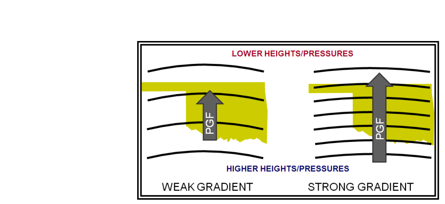
All wind begins with differences in atmospheric pressure. When one region of the atmosphere contains more densely packed air molecules than an adjacent region, a net force pushes air from the high-pressure area toward the low-pressure area. This is the pressure gradient force (PGF), and it is the fundamental engine that sets air in motion.
The word "gradient" here is key. A pressure gradient is the rate of pressure change over a given horizontal distance. You can see this directly on a surface analysis chart: the spacing between isobars (lines of equal pressure) tells you how steep the gradient is. Closely spaced isobars indicate a steep pressure gradient — a large pressure change over a short distance — which produces strong winds. Widely spaced isobars indicate a shallow gradient and gentle winds. This relationship is one of the most immediately useful pieces of weather chart literacy a pilot can develop.
The pressure gradient force acts perpendicular to the isobars, pointing directly from higher pressure toward lower pressure. If this were the only force acting on the air, wind would simply blow straight from highs to lows, and forecasting would be straightforward. But two other forces immediately go to work modifying the direction and speed of that initial motion.
The Coriolis Effect: The Great Deflector
The Earth rotates from west to east, completing one full rotation every 24 hours. Any object moving freely across the Earth's surface — including a parcel of moving air — appears, from a ground-based reference frame, to be deflected from a straight path. This apparent deflection is the Coriolis effect, named after Gaspard-Gustave de Coriolis, a French mathematician and scientist who mathematically described it in the 19th century.
In the Northern Hemisphere, the Coriolis effect deflects moving air to the right of its direction of travel. In the Southern Hemisphere, the deflection is to the left. For pilots operating in the United States, only the rightward deflection matters. As pressure gradient force accelerates air toward a low-pressure center, Coriolis deflection pushes that air to the right. The result is that air does not flow straight into the low; instead, it begins to curve. The air curves rightward so consistently that, at higher altitudes where friction is negligible, it ends up flowing nearly parallel to the isobars rather than across them.
This leads to one of the most important conceptual rules in aviation meteorology: at altitudes above the friction layer (roughly above 2,000 feet AGL), wind tends to flow counterclockwise around low-pressure systems and clockwise around high-pressure systems in the Northern Hemisphere. This balanced state — where the pressure gradient force and Coriolis force are in approximate equilibrium — produces what meteorologists call the geostrophic wind. The geostrophic wind is a useful theoretical concept because upper-level wind forecasts are largely based on it, and it explains why pilots flying at cruising altitude experience winds that are strongly linked to the isobar pattern on weather maps.
The Coriolis effect is essentially zero at the equator and increases in magnitude toward the poles. It is also negligible for small-scale, short-duration motions — this is why it does not affect the direction water drains from a sink, despite popular myth — but over the large scales and long durations of atmospheric motion, it is enormously significant.
Friction: Slowing and Backing the Wind Near the Surface
The third force, friction, operates primarily in the lowest layer of the atmosphere — called the planetary boundary layer, typically the lowest 2,000 feet AGL, though the exact depth varies with terrain and atmospheric stability. As moving air encounters the Earth's surface — trees, buildings, hills, ocean waves — it experiences drag that reduces its speed.
The reduction in wind speed caused by friction has an important secondary effect: it reduces the magnitude of the Coriolis deflection. Because Coriolis force is proportional to wind speed, slower surface winds experience less rightward deflection. This means that near the surface, the pressure gradient force is no longer perfectly balanced by Coriolis; the net result is that surface wind is deflected slightly back toward the low-pressure center, crossing the isobars at an angle rather than flowing parallel to them.
Over land surfaces with rough terrain, this crossing angle is typically 10° to 45° from the isobars toward lower pressure. Over smooth ocean surfaces where friction is lower, the angle is smaller and surface winds more closely resemble the geostrophic wind aloft.
This explains a phenomenon every instrument pilot eventually notices: wind direction and speed change with altitude. As you climb through the boundary layer, friction decreases, wind speed increases, and the wind direction veers (turns clockwise in the Northern Hemisphere) because Coriolis deflection becomes more dominant. Descending through the boundary layer, the reverse happens — wind speed decreases and wind backs (turns counterclockwise). This shift in wind direction with height is sometimes called wind shear and is a significant safety consideration during takeoff and landing.
How the Three Forces Work Together
In practice, the wind you experience at any moment and altitude is the product of all three forces acting simultaneously. High above the boundary layer, pressure gradient and Coriolis dominate, producing nearly geostrophic flow parallel to the isobars. Near the surface, friction slows the wind and reduces Coriolis influence, causing the wind to cross isobars at an inward angle toward the low. This inward flow near the surface is precisely why low-pressure centers produce convergence — surface air spiraling inward and upward — which drives cloudiness and precipitation. High-pressure centers produce divergence — air spiraling outward near the surface and descending from above — which suppresses clouds and produces fair weather.
For VFR pilots, this understanding has very practical implications. When you see a strong surface low on a prognostic chart, you can anticipate not just clouds and precipitation, but also strong and gusty surface winds that increase rapidly with altitude. For cross-country flight planning, knowing that winds aloft are more geostrophic helps you use upper-level wind forecast products (like the Winds and Temperatures Aloft Forecast, FB) to plan the most favorable route and altitude.
Key Numbers and Rules
- Pressure gradient and isobar spacing: Closer isobars = steeper gradient = stronger winds. This is directly readable from surface analysis and prognostic charts.
- Coriolis deflection: Always to the right in the Northern Hemisphere; increases with latitude and wind speed; essentially zero at the equator.
- Geostrophic wind: The theoretical wind resulting from balance of pressure gradient and Coriolis forces; dominates above the friction layer (~2,000 ft AGL).
- Boundary layer depth: Typically the lowest 2,000 ft AGL over land; depth varies with surface roughness and atmospheric stability.
- Surface wind crossing angle: Approximately 10°–45° across isobars toward lower pressure, depending on surface roughness.
- Northern Hemisphere circulation: Counterclockwise (cyclonic) around lows; clockwise (anticyclonic) around highs.
- Wind veers with altitude: In the Northern Hemisphere, wind direction generally turns clockwise (veers) as altitude increases through the boundary layer.
Common Test Traps
- Confusing the direction of Coriolis deflection: The FAA knowledge test expects you to know that in the Northern Hemisphere, Coriolis deflects wind to the right. Students who memorize "left" from Southern Hemisphere examples will miss these questions.
- Thinking surface wind flows parallel to isobars: It does not — friction causes surface wind to cross isobars at an angle toward lower pressure. Only upper-level (geostrophic) wind flows roughly parallel to isobars.
- Assuming wind speed is constant with altitude: Wind speed typically increases with altitude through the boundary layer as friction decreases. This matters for turbulence and wind shear planning.
- Forgetting that closely spaced isobars mean strong winds: Some test questions present surface analysis charts and ask you to identify the region of strongest winds. Always look for the tightest isobar spacing.
- Misidentifying circulation direction: Low-pressure systems spin counterclockwise (not clockwise) in the Northern Hemisphere. High-pressure systems spin clockwise. Mixing these up is a classic exam error and a real-world situational awareness failure.