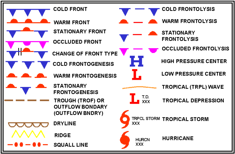
Weather fronts are the battlegrounds of the atmosphere — boundaries where air masses of different temperature, humidity, and density collide. For pilots, these boundaries are among the most important weather features to understand, because the weather produced along and near a front can range from mere turbulence and low ceilings to embedded thunderstorms, severe icing, and near-zero visibility. Knowing the type of front, how fast it is moving, and the characteristics of the air masses involved allows you to anticipate conditions well before you ever consult a METAR or TAF.
The FAA defines a front as the boundary between two air masses that differ in temperature and moisture. The three types most relevant to pilots are cold fronts, warm fronts, and stationary fronts. Each behaves differently, moves differently, and produces a different sequence of hazardous weather. Mastering these differences is essential both for the FAA knowledge test and for real-world aeronautical decision-making.
Cold Fronts: Fast, Violent, and Brief
A cold front marks the leading edge of a cold, dense air mass displacing warmer air. Because cold air is heavier, it wedges beneath the warm air ahead of it and forces it steeply upward. This rapid, forceful lifting is the key to understanding why cold frontal weather tends to be intense but relatively short-lived.
Cold fronts typically move at an average of roughly 20 to 25 knots, though fast-moving cold fronts can reach 30 knots or more, making them among the most rapidly moving of all frontal types. The slope of the frontal surface is steep — approximately 1:40 to 1:80 (one mile of vertical rise for every 40 to 80 miles of horizontal distance) — and that steepness concentrates the weather into a narrow, well-defined band.
Pre-Frontal and Frontal Conditions
Ahead of a fast-moving cold front, the warm air is unstable and moist. You may encounter a squall line — a line of thunderstorms that can develop 50 to 200 miles ahead of the front itself. These pre-frontal squalls can be severe and are especially dangerous because they may appear on radar before any official frontal passage warning. At the frontal boundary, cumulonimbus clouds, heavy rain, gusty and shifting winds, lightning, hail, and sudden drops in temperature are all possible. Visibility can plummet rapidly.
After frontal passage, conditions improve quickly. Temperatures fall noticeably, dew points drop, winds shift (typically from southwest to northwest in the Northern Hemisphere), pressure rises, and skies clear. This rapid clearing is a hallmark of cold front passage. The post-frontal air mass often brings excellent VFR flying weather, though scattered cumuliform clouds may linger for a short period.
Slow-moving cold fronts behave somewhat differently. When a cold front moves at less than about 15 knots, it resembles a warm front in many respects: the slope is shallower, lifting is more gradual, and the weather zone is broader and longer-lasting. Stratiform clouds and continuous precipitation can accompany a slow cold front, extending the period of IFR or marginal VFR conditions.
Warm Fronts: Gradual, Widespread, and Insidious
A warm front forms when a warm air mass advances and overrides retreating cooler air. Because warm air is less dense, it rises gently over the shallow wedge of cold air ahead of it. This produces a very gradual slope — approximately 1:150 to 1:300 — which spreads weather over an enormous geographic area, often hundreds of miles ahead of the surface front position.
Warm fronts typically move at only 10 to 25 knots, and their associated weather can persist for 12 to 24 hours or longer. This combination of slow movement and wide coverage makes warm fronts particularly challenging for pilots: the weather comes on gradually, can trap an aircraft in deteriorating conditions over a large area, and provides fewer obvious visual cues of imminent danger than the dramatic wall of a fast cold front.
The Classic Warm Front Cloud Sequence
As a warm front approaches from several hundred miles away, the cloud types appear in a predictable sequence: cirrus → cirrostratus → altostratus → nimbostratus. Pilots and meteorologists use this progression as a forecasting tool. Cirrus clouds may appear 300 to 500 miles ahead of the surface front, giving early warning. As the front closes in, clouds thicken and lower, ceilings drop, and continuous or intermittent precipitation begins. By the time nimbostratus dominates, widespread IFR conditions — low ceilings, rain or drizzle, and reduced visibility in fog and mist — are common.
Icing is a particularly serious warm-front hazard. The shallow cold air ahead of the surface front is often at or near freezing, and precipitation falling from warmer air aloft passes through this cold layer. The result can be freezing rain — a condition in which supercooled water droplets or rain freezes on contact with aircraft surfaces, producing the most dangerous form of structural icing. Warm fronts also favor the formation of precipitation-induced fog, as rain falling into the cool air ahead of the front saturates the air near the surface, further degrading visibility ahead of and during passage.
After warm frontal passage, temperatures rise, dew points increase, wind shifts (usually from southeast to south or southwest), and pressure briefly steadies before falling again. Skies may clear somewhat, but ceilings can remain low if the warm air is very moist, and fog or low stratus can persist. The relief of post-warm-front weather is often more modest and temporary than post-cold-front improvement.
Stationary Fronts: Persistent and Prolonged
A stationary front occurs when neither air mass is strong enough to displace the other, and the frontal boundary essentially stalls. The surface winds on each side of a stationary front blow nearly parallel to the boundary rather than perpendicular to it. Because the front is barely moving, it can produce days of continuous IFR weather over the same geographic region.
The weather associated with a stationary front is similar in character to warm-front weather: widespread low ceilings, fog, drizzle, and continuous precipitation. Icing hazards are significant in the same ways. The primary difference — and the primary hazard — is the duration. A stationary front may persist for several days, making VFR cross-country flying impossible along its path without an instrument rating and an aircraft equipped for flight in actual IMC.
Occasionally, a stationary front will begin to move again as one of the air masses gains strength. If the cold air starts advancing, the front evolves into a cold front; if the warm air pushes forward, it becomes a warm front. Weather forecasters and pilots both watch stationary fronts carefully for signs of movement.
Why Frontal Weather Matters to Pilots
Fronts concentrate the most hazardous aviation weather: thunderstorms, low IFR, structural icing, turbulence, wind shear, and rapidly changing conditions. Even a VFR-only pilot needs to understand fronts because a front can transform a perfect flying day into life-threatening conditions within a matter of hours — or even minutes in the case of a fast cold front. Instrument-rated pilots must understand fronts to plan alternates, avoid icing, and interpret weather products accurately.
The FAA emphasizes that a pilot's weather evaluation should always include frontal activity from the surface analysis chart, the 12-hour and 24-hour prognostic charts (prog charts), AIRMETs and SIGMETs, and pilot reports (PIREPs). A SIGMET is issued for severe icing, severe turbulence, and other conditions that may affect all aircraft; AIRMETs cover more moderate hazards. Both are directly linked to frontal activity.
Key Numbers and Rules
- Cold front slope: approximately 1:40 to 1:80 — steep, concentrated weather zone.
- Cold front speed: average roughly 20–25 knots; fast-moving cold fronts can reach 30 knots or more; pre-frontal squalls possible 50–200 miles ahead.
- Warm front slope: approximately 1:150 to 1:300 — shallow, widespread weather zone.
- Warm front speed: typically 10–25 knots; IFR conditions may persist 12–24+ hours.
- Warm front cloud sequence: cirrus → cirrostratus → altostratus → nimbostratus (leading cirrus commonly cited up to 300–500 miles ahead of surface front).
- Stationary front: nearly no movement; can produce days of IFR weather over the same area.
- Freezing rain hazard: most common with warm fronts and stationary fronts due to cold air underrunning warm precipitation.
- Wind shift: passage of any front is marked by a noticeable wind shift and pressure change.
Common Test Traps
- Assuming cold fronts always produce thunderstorms. Slow-moving cold fronts can produce stratiform weather similar to a warm front, with clouds, steady rain, and poor visibility rather than convective activity.
- Confusing which front covers a wider area. Warm fronts affect a much larger geographic region than cold fronts due to their shallower slope — weather spreads hundreds of miles ahead of the surface position.
- Underestimating the icing risk with warm fronts. Freezing rain beneath the warm front's overriding air is more hazardous than the visible cloud bank might suggest. Many tests emphasize that warm fronts are associated with the most dangerous icing conditions.
- Expecting rapid improvement after a warm front. Unlike cold fronts — which clear quickly — warm frontal passage often leaves lingering low ceilings, fog, and reduced visibility, especially when the warm air mass is very moist.
- Overlooking stationary fronts on weather charts. A stationary front is depicted with alternating blue (cold) and red (warm) barbs or pips pointing in opposite directions on each side of the line, while an occluded front is depicted with alternating purple symbols (triangles and semicircles) all pointing together in the direction the front is moving. Don't confuse the two symbologies.