Fog is among the most hazardous weather phenomena a pilot will ever encounter. It can reduce visibility to near zero in minutes, trap aircraft on the ground, and turn a routine departure or approach into a life-or-death situation. Despite looking identical from the cockpit, not all fog is created the same way — and understanding how each type forms, where it tends to appear, and when it will dissipate is exactly the knowledge you need to make smart go/no-go decisions and to answer FAA knowledge test questions correctly.
Two fog types dominate private pilot study materials and real-world flying alike: radiation fog and advection fog. They share the same basic physics — water vapor condensing into tiny suspended droplets when air is cooled to its dew point — but their causes, behaviors, and dissipation patterns are strikingly different. Let's break both down completely.
What Is Radiation Fog?
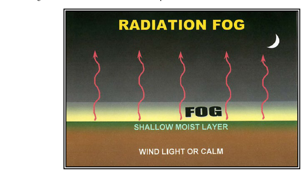
Radiation fog is the classic "ground fog" most student pilots first visualize when they hear the word fog. It forms at night or in the early morning hours over land when the ground loses heat through terrestrial radiation — the process by which Earth's surface radiates infrared energy into the atmosphere after the sun sets. As the ground cools, the thin layer of air directly in contact with it also cools. When that air cools to its dew point, the water vapor in it condenses and fog forms, essentially resting on the surface.
Conditions Required for Radiation Fog
- Clear skies: Cloud cover acts like a blanket, absorbing and re-radiating heat back toward Earth. Clear skies allow maximum radiative cooling of the surface, which is why radiation fog almost never forms on overcast nights.
- High relative humidity: The air must already contain significant moisture so that only a modest drop in temperature reaches the dew point. A small temperature-dew point spread at sunset is a strong indicator.
- Calm or very light winds (generally less than about 5 knots): Calm air allows a shallow, distinct surface-cooling layer to develop. Slight air movement can gently mix the cooled air, helping deepen the fog layer slightly. However, stronger winds (above about 10 knots) mix the cooled air so thoroughly with drier air aloft that fog cannot form — the moisture gets diluted.
- Land surface: Water bodies do not cool quickly enough through radiation to produce this fog type. Radiation fog is a land-based phenomenon.
How Radiation Fog Grows and Deepens
Initially, radiation fog may be only a few feet deep — a thin wispy layer that a pilot might taxi through without realizing it. As the night progresses and the ground continues to cool, the fog can deepen to hundreds of feet. If the temperature-dew point spread is small over a large area and winds remain light, dense radiation fog patches can develop and merge into widespread low-IFR conditions by early morning. The deepest and densest radiation fog typically occurs just before or around sunrise, when ground temperatures have reached their overnight minimum.
Dissipation of Radiation Fog
Here is one of the most important — and most testable — facts about radiation fog: it dissipates as the sun rises and heats the ground. Once solar energy begins warming the surface, the ground temperature rises above the dew point, the lowest layer of fog evaporates, and the fog "burns off" from the bottom upward. This means a pilot on the ground may watch the ceiling rise as the fog lifts — a good sign. Dissipation is typically well underway within a few hours after sunrise. The timing depends on how thick and dense the fog became overnight and how strong the solar heating is.
A critical point for flight planning: radiation fog tends to be a localized, morning phenomenon. If your departure airport is fogged in at sunrise, waiting a couple of hours on a sunny day often resolves the problem. But never count on a specific dissipation time without current weather data, because thick fog can linger well into the morning under the right conditions.
What Is Advection Fog?
Advection fog has a completely different origin. Rather than depending on nighttime cooling of the ground, it forms when warm, moist air moves horizontally over a cooler surface. As the moving air mass contacts the cooler surface, the lowest layers of that air are chilled to their dew point and condensation occurs. The term "advection" simply refers to the horizontal movement of an air mass — contrast that with "radiation," which involves heat transfer by electromagnetic energy from the ground upward.
Conditions Required for Advection Fog
- A significant temperature difference: The surface must be noticeably cooler than the incoming air mass. Common situations include warm moist maritime air flowing over cold ocean currents (the classic example is the Pacific Coast of North America) or warm Gulf air moving northward over cooler land in winter and spring.
- Adequate moisture: The incoming air must be humid enough that cooling it to the surface temperature brings it to saturation.
- Wind: Unlike radiation fog, advection fog requires wind to transport the air mass over the cooler surface. Moderate winds, often cited around 15 knots, are favorable for forming and mixing advection fog, but winds much stronger than that tend to lift the fog into a layer of low stratus rather than sustain it as surface fog. This is a key difference — stronger winds suppress radiation fog but can help sustain advection fog up to a point.
Geographic and Seasonal Patterns
Advection fog is particularly common along coastlines and in coastal valleys. The famous summer fog of the California coast — where warm Pacific air flows onshore over the cold California Current — is a textbook advection fog. It can persist for days and cover enormous geographic areas, unlike radiation fog which tends to burn off each morning. Advection fog can also form over land in late winter and spring when warm moist air surges northward over still-cold ground, affecting airports many miles from any coast.
Dissipation of Advection Fog
This is where advection fog becomes especially challenging from a pilot's perspective: advection fog does not simply burn off with morning sunshine the way radiation fog does. Because it depends on a continuing supply of warm moist air flowing over a cool surface, it can persist all day and night as long as the wind pattern and temperature differential are maintained. Dissipation requires either a change in wind direction that cuts off the supply of warm moist air, or a warming of the underlying surface until the temperature differential disappears. In some locations — such as coastal California — advection fog can persist for several days in a row without meaningful breaks.
Why This Distinction Matters for Pilots
Understanding which type of fog you are dealing with shapes every aspect of your flight planning and decision-making. Radiation fog at your destination airport in the early morning? There is a reasonable chance (not a guarantee) it will improve by mid-morning. Advection fog blanketing the coast? Alternate planning, diversion options, and realistic expectations about the entire day's flyability become critical. A fog layer that shows no sign of burning off by midday is almost certainly not radiation fog — and that should change your decisions accordingly.
From a regulatory standpoint, fog affects VFR minimums directly. If the reported ceiling drops below 1,000 feet AGL or visibility falls below 3 statute miles at a controlled airport, basic VFR flight is not legal for most student and private pilots. Instrument-rated pilots must apply the appropriate approach minimums, which vary considerably by approach type and category — some Category I ILS approaches allow visibility as low as 1/2 to 3/4 statute mile, while other approaches may require more or, with special authorization, less. Neither rating allows you to fly inside a fog bank under VFR.
Key Numbers and Rules
- Radiation fog requires clear skies, high humidity, and calm or very light winds (generally less than about 5 knots). Stronger winds prevent its formation by mixing the cooled surface air with drier air aloft.
- Advection fog requires horizontal air movement — wind is necessary for formation and persistence. It is not limited to nighttime and does not require clear skies.
- Radiation fog deepens overnight and is typically thickest near sunrise, then burns off from the bottom up after solar heating begins.
- Advection fog can persist for multiple days and is not dependent on the diurnal (day-night) cycle for dissipation.
- Temperature-dew point spread of about 4°F (roughly 2–3°C) or less is a commonly cited rule-of-thumb threshold suggesting fog or low clouds are possible — a small spread at field level warrants close attention, though this is an approximation rather than a fixed regulatory value.
- VFR minimums at controlled airports: ceiling at least 1,000 feet AGL and visibility at least 3 statute miles (14 CFR 91.155).
Common Test Traps
- Confusing wind's role: The FAA frequently tests the fact that calm or very light winds favor radiation fog while moderate winds can help sustain advection fog (up to a point, beyond which it lifts into stratus). Do not apply the same wind logic to both fog types.
- Assuming all fog burns off by midday: Only radiation fog reliably dissipates with solar heating. Advection fog can persist all day and night, and no amount of waiting guarantees it will improve.
- Forgetting that radiation fog needs clear skies: Overcast conditions prevent the ground cooling that drives radiation fog formation. If it is cloudy, radiation fog is not the culprit.
- Mixing up "upslope fog" with radiation or advection fog: Upslope fog forms when moist air is forced up a terrain slope and cools adiabatically — it is a separate type not driven by surface radiation or horizontal advection over a cool surface.
- Getting the dissipation direction backwards: Radiation fog burns off from the bottom upward, not from the top down. A rising ceiling in the morning is a sign of radiation fog starting to break — do not confuse a lifting fog layer with improving conditions at the surface immediately.
Mastering the differences between radiation and advection fog will serve you on the FAA knowledge test and throughout your entire flying career. Fog has been a factor in countless accidents that began with a pilot who did not fully understand what they were flying into — or what they were waiting for on the ground. Build the habit of checking temperature-dew point spreads, overnight sky conditions, and wind forecasts every time you file a flight plan, and you will have a decisive edge in recognizing fog risk before it becomes a problem.