Of all the weather phenomena that ground aircraft or catch pilots off guard, fog is among the most insidious. It can reduce visibility from miles to feet in a matter of minutes, and it can linger far longer than forecast. For instrument-rated pilots, fog is not just an inconvenience — it is a certification-relevant, legally binding weather limitation that demands a systematic understanding. Knowing how fog forms — and which type you are dealing with — changes your entire departure calculus: when to launch, whether your alternate is genuinely usable, and how quickly conditions might improve or deteriorate.
This article walks through each major fog type recognized by the FAA, explains the meteorological mechanics behind each, and ties those mechanics directly to IFR departure planning decisions. Whether you are reviewing for the Instrument Rating knowledge test or preparing for a real-world preflight briefing, the goal is the same: translate atmospheric physics into actionable cockpit judgment.
What Fog Actually Is
Fog is simply a cloud with its base at or near the surface, officially defined as reducing visibility to less than 5/8 statute mile. When visibility drops below 5/8 SM but the restriction is at the surface level, it is reported as fog (FG) in a METAR. Mist (BR) is reported when visibility is between 5/8 and 6 SM with relative humidity high enough to produce visible water droplets. Understanding this reporting distinction matters because IFR departure and alternate minima are tied to specific visibility and ceiling values — and fog is what most commonly pushes conditions to those thresholds.
Fog forms whenever air is cooled to its dew point, or when enough moisture is added to saturate the air, causing water vapor to condense into tiny suspended droplets. The type of fog depends on the mechanism that brings temperature and dew point together.
The Five Major Fog Types
1. Radiation Fog
Radiation fog is the most common fog type in inland areas and the one most frequently tested on the FAA Instrument Rating knowledge exam. It forms on clear nights when the ground radiates heat rapidly into space, cooling the surface and the air immediately above it. As the surface temperature drops toward the dew point, moisture condenses into a shallow fog layer that typically hugs the ground.
Key conditions that favor radiation fog: clear skies (no cloud blanket to trap heat), light winds (2–7 knots — enough to mix the fog layer slightly and deepen it, but not enough to disperse it), high relative humidity at sunset, and a long night (more time for radiational cooling). Calm winds produce a very shallow ground fog that may not affect ceilings significantly; a gentle breeze deepens the layer by mixing the cooled air upward.
The critical planning insight for departures: radiation fog typically forms after sunset, reaches its thickest density around sunrise, and then burns off from the top down as solar heating warms the ground. Departure delays of 1–3 hours past sunrise are common. The fog does NOT simply thin uniformly — it often maintains low visibility at the surface while the ceiling lifts, and then clears rapidly once the process begins. Forecasts often estimate burn-off time, but local topography (valleys trap fog longer) can extend it significantly.
2. Advection Fog
Advection fog forms when warm, moist air moves horizontally over a cooler surface, cooling the air to its dew point. It is especially common along coastlines, where onshore flow brings humid marine air over cooler land or water surfaces. Unlike radiation fog, advection fog does not require calm winds — in fact, it is associated with sustained winds and can develop at any time of day or night.
This makes advection fog particularly hazardous for IFR planning. It can roll in quickly, persist for days if the wind pattern does not change, and affect large geographic areas simultaneously. Famous examples include San Francisco's summer fog, which is driven by onshore marine flow over cold coastal upwelling waters. For departure planning, advection fog is difficult to wait out — if the large-scale wind pattern sustains the flow of moist air over the cool surface, conditions will not improve until the synoptic pattern shifts.
3. Upslope Fog
Upslope fog forms when moist air is pushed up a terrain slope by wind, cooling adiabatically as it rises until it reaches the dew point. This type is common on the eastern slopes of the Rockies and the Appalachians. Like advection fog, it requires wind and does not depend on nighttime cooling. Upslope fog can affect airports at the base or mid-slope of terrain and may cap the area in IFR conditions for extended periods while airports in flat terrain nearby remain VFR.
For departure planning, upslope fog demands attention to the orientation of terrain relative to the wind and to your intended routing. Flying out of an upslope fog environment toward lower terrain may provide an escape route; flying further upslope will worsen conditions rapidly.
4. Steam Fog (Evaporation Fog)
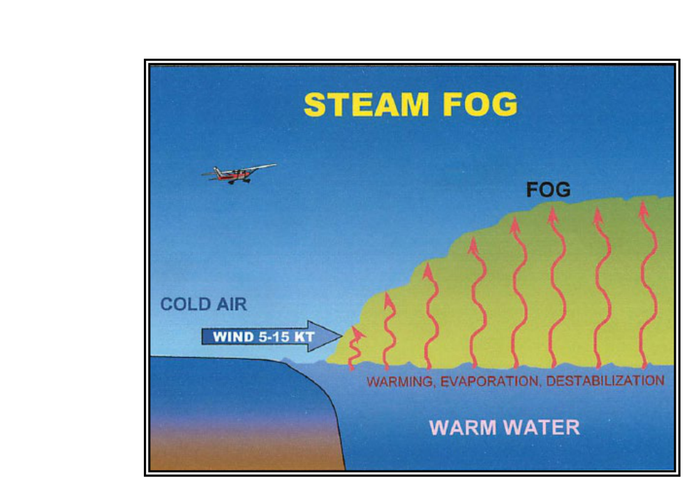
Steam fog, also called evaporation fog or Arctic sea smoke, forms when cold, dry air moves over a warmer water surface. Water evaporates rapidly into the cold air, which quickly becomes saturated and condenses into wisps of fog rising from the surface. It appears as rising steam or smoke over lakes, rivers, and coastal waters.
For instrument pilots operating near large bodies of water in autumn and early winter — when water retains summer warmth but air masses have chilled — steam fog is a realistic hazard. It tends to be shallow (a few hundred feet) but can significantly reduce surface visibility. It is also associated with low-level turbulence and icing, because the rising moist air can create convective instability just above the surface.
5. Precipitation-Induced Fog (Frontal Fog)
Frontal or precipitation-induced fog forms when rain falling through cooler air evaporates, adding moisture to the air below until it saturates and fog develops. It is most commonly associated with warm fronts, where widespread precipitation ahead of the front falls into the cooler air mass beneath. This type can produce simultaneous low ceilings, reduced visibility, and precipitation — a challenging combination for any IFR operation.
Frontal fog often accompanies the worst IFR conditions: embedded convection, icing, and the rapid deterioration that characterizes frontal passage. Departure planning must account for the possibility that conditions may be below minimums at the departure airport while the front is close and also at potential alternates, since frontal fog can affect a wide geographic swath.
Why Fog Type Matters for IFR Departure Planning
The FAA's IFR departure rules under 14 CFR Part 91 do not set specific weather minimums for departure (for Part 91 operators), but they do require pilots to comply with any published Takeoff Minimums and Obstacle Departure Procedures (ODPs) at airports with published instrument procedures. More importantly, a pilot must always consider whether an emergency return or diversion is possible given the departure environment.
Fog type shapes three key planning questions:
- Will conditions improve or worsen? Radiation fog has a predictable burn-off pattern tied to solar heating. Advection fog is tied to synoptic wind patterns and may persist indefinitely. Knowing the type tells you whether waiting is productive.
- Is your alternate genuinely viable? If advection fog or frontal fog is driving IMC over a broad region, your filed alternate may be socked in simultaneously. The alternate minimums under 14 CFR Part 91.169(c) require careful cross-checking against area fog patterns.
- What is the takeoff escape route? If you depart into fog and experience an emergency requiring immediate return, what are actual conditions at the airport? A shallow radiation fog layer may allow a precision approach return; a thick advection fog bank may not.
Key Numbers and Rules
- Fog definition: visibility less than 5/8 statute mile at the surface.
- Radiation fog peak: typically thickest at or just after sunrise; often dissipates 1–3 hours after sunrise.
- Wind and radiation fog: calm winds = very shallow layer; 2–7 knots = deeper, more significant layer; winds above ~15 knots typically prevent formation by mixing the air.
- Part 91 alternate minimums (14 CFR 91.169(c)): unless the airport has an approved standard instrument approach procedure with different published alternate minimums, the standard alternate minima apply — for an airport with at least one operational navigation facility providing a straight-line non-precision approach, forecast ceiling at least 800 feet and visibility at least 2 statute miles; for an airport with at least one operational precision approach, forecast ceiling at least 600 feet and visibility at least 2 statute miles (the familiar "600-2 / 800-2" rule, sometimes summarized with the 1-2-3 rule for alternate requirement determination).
- Dew point spread: a temperature/dew point spread of 4°F (2°C) or less at or near the surface is a strong indicator of fog or low cloud formation potential.
- Freezing fog (FZFG): reported when fog is composed of supercooled water droplets and temperature is at or below 0°C — significant icing hazard on surfaces and during approach.
Common Test Traps
- Radiation fog and wind: the FAA frequently tests the detail that radiation fog requires light wind, not calm wind, to deepen significantly. A completely calm night often produces only very shallow ground fog, not a thick IFR layer.
- Advection fog timing: many students assume fog is always a nighttime phenomenon. Advection fog can form and persist at any hour; it is not dependent on nocturnal cooling. Test questions often probe this distinction.
- Fog vs. mist reporting: know that FG is less than 5/8 SM visibility and BR (mist) is 5/8 to less than 6 SM. Questions may present a METAR with BR and ask whether IFR conditions exist — BR alone may or may not result in IFR depending on the ceiling.
- Frontal fog and alternates: a common scenario question asks whether a filed alternate is acceptable when frontal fog is covering the region. The correct approach is to verify that the alternate forecast meets the legal minimums AND that the fog type's geographic scope does not invalidate the alternate's utility.
- Burn-off expectations: the exam may ask what causes radiation fog to dissipate. The answer is solar heating of the ground (insolation) — not wind increase, not frontal passage. Upward mixing from surface warming erodes the fog layer from below.
Understanding fog formation is not an academic exercise for instrument pilots — it is the foundation of sound weather decision-making. A pilot who can look at a surface analysis, a forecast discussion, and a METAR and say "this is radiation fog — it will be gone by 10 AM" or "this is advection fog — I need a completely different plan" is operating at the level of professionalism and safety that the instrument rating demands.