When you file IFR and study your approach plates, you will notice that a single GPS approach chart can list several different sets of minimums stacked on top of one another — LPV, LNAV/VNAV, LNAV, and sometimes circling minimums. Which row you are legally authorized to fly depends almost entirely on one question: does your aircraft have a Wide Area Augmentation System (WAAS) GPS receiver that has been properly certified and approved? The answer determines whether you have precision-like approach capability down to 200 feet AGL or whether you are limited to a non-precision style approach with much higher minimums. This distinction shows up repeatedly on FAA knowledge tests and is one of the most practically important concepts an instrument pilot can master.
Understanding WAAS versus non-WAAS GPS capability requires a solid grasp of how satellite navigation works, what augmentation means, and how the FAA's approach certification system translates that technology into specific minimums on an approach chart. Let's build that understanding from the ground up.
How the GPS Signal Works — and Why It Needs Help
The FAA's Global Positioning System (GPS) relies on a constellation of satellites that broadcast timing signals. A receiver calculates its position by measuring the tiny differences in signal arrival time from multiple satellites — a process called trilateration. In its raw, unaugmented form, the civilian GPS signal has position errors that can be several meters or more, caused by atmospheric distortion (primarily the ionosphere bending the signal), satellite clock drift, and receiver noise. For en-route navigation, those errors are acceptable. For flying an approach to minimums within a few hundred feet of terrain and runway thresholds, they are not.
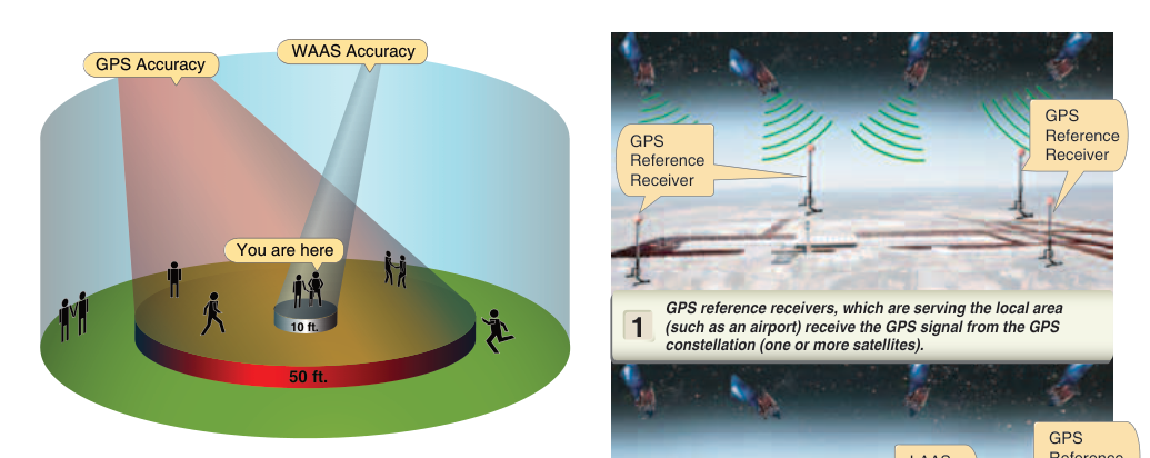
To make GPS precise enough for approaches, the FAA built the Wide Area Augmentation System (WAAS). A network of precisely surveyed ground reference stations across the United States continuously measures the GPS signals they receive and compares the measured position to their known exact position. That error data is sent to master stations, which compute correction messages and upload them to geostationary satellites. Those satellites then broadcast the corrections on the same frequency as GPS. A WAAS-capable receiver picks up these correction messages and applies them in real time, dramatically improving both accuracy and integrity. WAAS-corrected position accuracy is typically better than approximately 1–2 meters horizontally and 2–3 meters vertically (95% of the time) — accurate enough to support approaches comparable to an ILS.
What Non-WAAS GPS Can Do
Before WAAS became operational in 2003, the FAA certified a generation of IFR-approved GPS receivers under Technical Standard Order TSO-C129 (and later TSO-C196). These receivers provide lateral guidance only — they can tell you whether you are left or right of the extended centerline, but they cannot provide approved vertical guidance derived from the satellite signal itself. Non-WAAS GPS receivers are authorized to fly LNAV (Lateral Navigation) minimums on an RNAV (GPS) approach. LNAV is a non-precision approach segment: it has a minimum descent altitude (MDA) rather than a decision altitude (DA), and the pilot descends to the MDA and then flies level while looking for the runway environment. LNAV MDAs vary considerably depending on terrain, obstacles, and airport-specific factors, so no single typical range applies to every location.
Non-WAAS GPS receivers can also be used to fly Localizer Performance (LP) approaches at airports where LP minimums are published. LP is a lateral-only approach (like LNAV but with tighter angular guidance similar to a localizer) available only at certain locations. However, LP is far less common than LPV in the current approach inventory.
What WAAS GPS Unlocks
A WAAS-capable receiver certified to TSO-C145 or TSO-C146 (the WAAS standards) can provide both lateral and vertical guidance directly from the satellite signal — a capability called Satellite-Based Augmentation System (SBAS) guidance. This opens up two important approach types that non-WAAS receivers cannot legally fly:
- LPV (Localizer Performance with Vertical Guidance): The gold standard of GPS approaches. LPV uses angular guidance (like an ILS glidepath, typically 3 degrees) and has a Decision Altitude (DA) rather than an MDA. Many LPV approaches publish DAs as low as 200 feet HAT (Height Above Touchdown) with visibility as low as 1/2 statute mile — minimums identical to a Category I ILS. Because LPV has vertical guidance and a DA, the pilot flies a continuous descending glidepath and makes a go/no-go decision at the DA, not a level-off and search.
- LNAV/VNAV (Lateral Navigation / Vertical Navigation): WAAS receivers can also fly LNAV/VNAV, which provides a computed vertical path (typically 3 degrees) down to a DA. LNAV/VNAV DAs vary considerably by airport and obstacle environment and are generally higher than LPV, though they cannot be reliably summarized as falling into a single narrow range, because the vertical accuracy requirement is less stringent. Barometric VNAV (Baro-VNAV) can also fly LNAV/VNAV if the aircraft is so equipped, but that is a separate authorization and has cold-temperature limitations not present with WAAS.
The practical hierarchy, from best minimums to highest, is: LPV → LNAV/VNAV → LNAV. A WAAS receiver will automatically sequence to the best available minimums the aircraft is capable of flying, based on current signal integrity. If WAAS signal protection levels are not met during the approach, the receiver will alert the pilot and the approach must be discontinued or flown to LNAV minimums.
Why It Matters for Safety and Operations
The difference between an LPV DA of 200 feet and a higher LNAV MDA is enormous in real-world operations. At busy periods of low IMC — think a 300-foot overcast with 3/4-mile visibility — an aircraft with LPV can land legally while an LNAV-only aircraft cannot. Over a flying career, that difference translates to fewer diversions, fewer fuel emergencies caused by holding for weather, and fewer decisions to attempt a marginal approach. More importantly, flying a stabilized glidepath to a DA is statistically safer than descending to an MDA and then flying level in reduced visibility searching for the runway — the latter is a scenario associated with controlled flight into terrain (CFIT) accidents.
From a regulatory standpoint, the aircraft's avionics installation approval, TSO certification of the equipment, and the Approved Flight Manual Supplement (AFMS) — guided by standards such as AC 20-138, Airworthiness Approval of Positioning and Navigation Systems — govern whether a specific GPS installation is authorized for IFR use and which approach types it may fly. Pilots must verify that their specific GPS installation — not just the box, but the installation approval for that airframe — is authorized for WAAS approaches. A WAAS-capable navigator installed without a compliant AFMS may not be used for WAAS approaches.
Key Numbers and Rules
- LPV minimums: DA as low as 200 feet HAT / 1/2 SM visibility — comparable to Cat I ILS.
- LNAV/VNAV minimums: DA generally higher than LPV, varying by airport and obstacle environment; WAAS required (or Baro-VNAV with separate authorization).
- LNAV minimums: MDA, varying widely by location and terrain; accessible to non-WAAS TSO-C129/C196 receivers.
- WAAS TSO standards: TSO-C145 (airborne antenna) and TSO-C146 (stand-alone equipment) — look for these in the avionics documentation.
- Non-WAAS TSO standards: TSO-C129 and TSO-C196.
- WAAS accuracy: Typically approximately 1–2 m horizontal, 2–3 m vertical (95% of the time).
- LPV approaches are not classified as precision approaches under ICAO definitions, but they provide equivalent minimums to a Category I ILS in the U.S. regulatory system (they are classified as APV — Approach with Vertical Guidance).
- For Part 91 operations, pilots generally do not need a special rating or authorization beyond their instrument rating to fly LPV approaches — WAAS equipment approval and a compliant AFMS are the key requirements; operators conducting Part 121/135 flights may have additional operator-specific training or authorization requirements.
Common Test Traps
- LPV is not an ILS. The FAA written test sometimes presents LPV as a precision approach. Under ICAO standards, LPV is an APV (Approach with Vertical guidance), not a precision approach — even though its minimums can match a Cat I ILS. Know the distinction: precision approaches use ground-based lateral and vertical guidance (ILS, PAR); LPV uses SBAS satellite guidance.
- Non-WAAS GPS cannot fly LPV. A common trap is assuming any IFR-approved GPS can use any row of minimums. TSO-C129 receivers are limited to LNAV (and LP where published). Only TSO-C145/C146 WAAS receivers can fly LPV and LNAV/VNAV.
- MDA vs. DA confusion. LNAV uses an MDA — you level off and search. LPV and LNAV/VNAV use a DA — you make a decision at that altitude and immediately execute a missed approach if the runway environment is not in sight. Mixing these up on the test (and in the cockpit) is dangerous.
- AFMS authorization matters. The receiver being WAAS-capable on the bench does not automatically mean the installation is approved for WAAS approaches in your aircraft. The AFMS must specifically authorize WAAS (LPV) operations for that airframe installation.
- WAAS is automatic, but not always available. If WAAS signal integrity falls below required levels during an approach, the receiver will alert and the pilot must revert to LNAV minimums or execute a missed approach. WAAS is not guaranteed 100% of the time, though outages are rare in the contiguous United States.