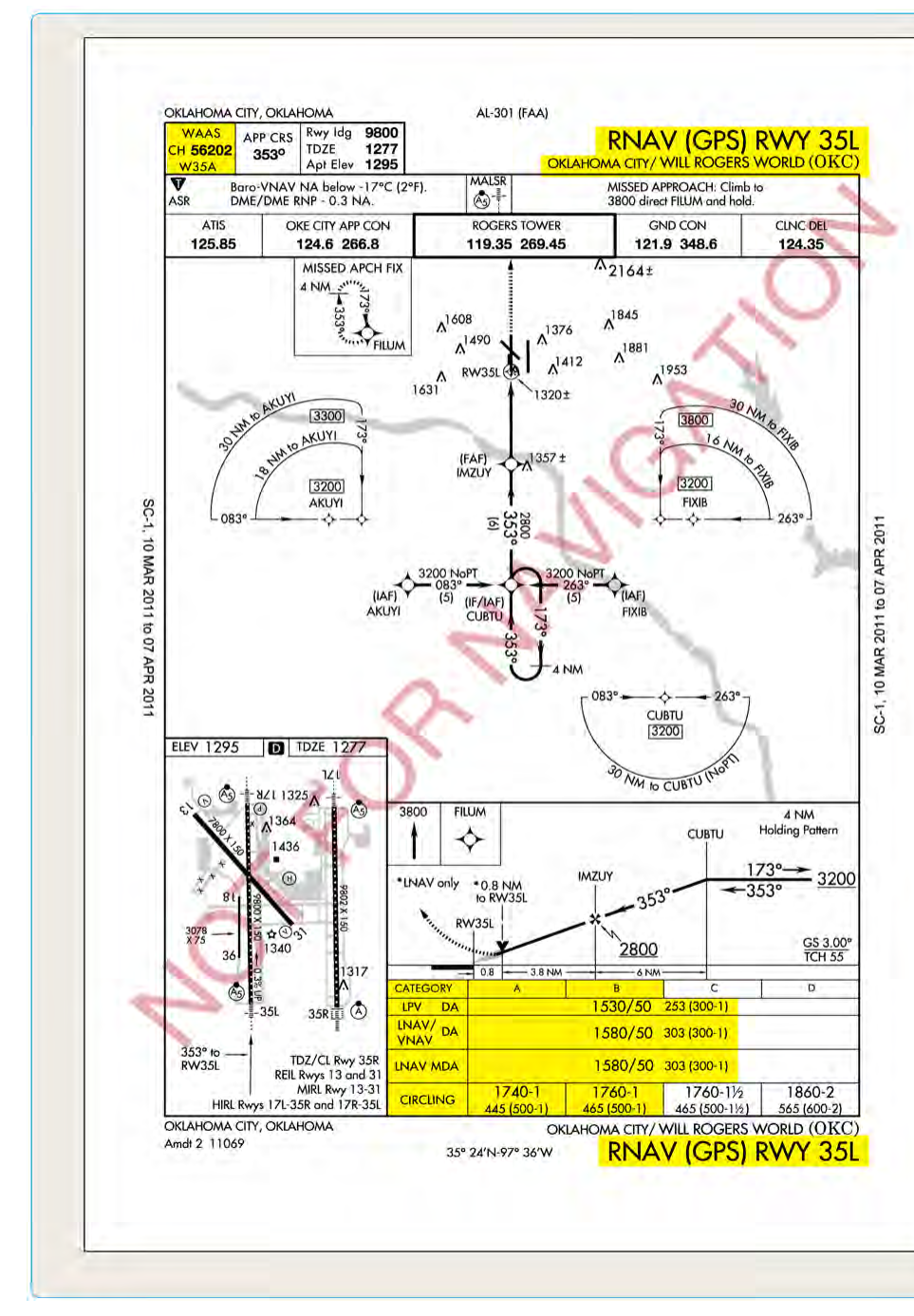
When you pull up an RNAV (GPS) approach plate, you'll notice the minimums section is divided into several rows, each labeled differently: LNAV, LNAV/VNAV, and LPV. To the uninitiated, these look like an alphabet soup of acronyms, but each line represents a distinct type of approach with its own equipment requirements, guidance architecture, and allowable decision altitude. Understanding the differences is not just an exam matter — it directly determines how low you can legally descend and how precisely the avionics will guide you to the runway on an IMC day.
All three minima lines live on the same approach chart and use the same underlying GPS-based lateral course. What differentiates them is how vertical guidance is provided (or not), what integrity monitoring backs that guidance, and whether the approach is classified as a precision approach, an approach with vertical guidance (APV), or a non-precision approach. The FAA defines these categories in the Instrument Procedures Handbook and the Instrument Flying Handbook, and they map directly to ICAO approach classifications used worldwide.
LNAV: Lateral Navigation Only
LNAV stands for Lateral Navigation. It is the baseline minima line on an RNAV (GPS) approach and requires only a GPS receiver that meets the TSO-C129 or TSO-C196 standard (or equivalent). LNAV provides horizontal course guidance only — the approach is flown like a traditional non-precision approach (NPA), meaning there is no published glidepath built into the avionics guidance. The pilot descends in a step-down fashion using published step-down fixes and then to the Minimum Descent Altitude (MDA).
Because LNAV is a non-precision approach, the published minimum is an MDA rather than a Decision Altitude (DA). You descend to the MDA, level off (or arrest the descent), and look for the runway environment. If you don't see it before the Missed Approach Point (MAP), you execute a missed approach. The typical MDA for an LNAV approach is higher than LPV or LNAV/VNAV minima — often 400 to 600 feet AGL or more, depending on obstacles and terrain — because the procedure must account for the absence of vertical guidance and the need to protect a broader obstacle clearance surface.
LNAV minima are the most widely available because the equipment bar is lowest. Almost any IFR-certified GPS navigator can fly LNAV. However, the lack of vertical guidance increases workload and accident risk, which is why the FAA actively encourages pilots to use the lowest available minima line their equipment supports.
LNAV/VNAV: Adding Baro-VNAV Vertical Guidance
LNAV/VNAV adds a computed vertical path to the lateral GPS guidance, but that vertical path is derived from the aircraft's barometric altimeter system rather than satellite geometry. The avionics compute a constant-angle glidepath (typically 3°) using barometric altitude data and drive the vertical deviation indicator accordingly. This is called Baro-VNAV. Because it relies on the air data computer and a correctly set altimeter, temperature errors become significant — cold temperatures cause the aircraft to fly lower than indicated, so many LNAV/VNAV procedures have published temperature restrictions (often around -15°C or colder) below which the approach is not authorized without cold temperature altitude corrections.
LNAV/VNAV is classified as an Approach with Vertical Guidance (APV) — not a precision approach, but not a plain non-precision approach either. It sits in the middle category. Because vertical guidance is provided, the published minimum is a Decision Altitude (DA) rather than an MDA. At the DA, if the runway environment is not in sight, the pilot immediately executes a missed approach — there is no leveling off and hunting for the runway.
To fly LNAV/VNAV, the aircraft must have an IFR-approved GPS coupled to a flight management system or navigator capable of computing and displaying a vertical deviation, and the aircraft must have an air data system feeding accurate baro data to the avionics. Many modern glass-panel aircraft equipped with systems like the Garmin G1000 or GNS 430W/530W with VNAV capability meet this requirement. Typical LNAV/VNAV DAs are lower than LNAV MDAs — commonly in the 300–400 feet AGL range — reflecting the improved vertical guidance and reduced obstacle clearance requirements.
LPV: The Precision-Like Standard
LPV stands for Localizer Performance with Vertical Guidance. This is the premium minima line, offering the lowest published DAs on RNAV (GPS) approaches — sometimes as low as 200 feet HAT (Height Above Touchdown), equivalent to a Category I ILS. LPV approaches are enabled by WAAS (Wide Area Augmentation System), the FAA's network of ground reference stations and geostationary satellites that computes differential GPS corrections and broadcasts integrity data. WAAS increases GPS accuracy from roughly ±100 meters to approximately ±3 meters horizontally and provides reliable vertical accuracy as well.
Unlike LNAV/VNAV, the vertical guidance for LPV comes directly from the WAAS-corrected GPS signal — no barometric altimeter is involved in computing the glidepath. This means LPV is immune to temperature-induced altimetry errors and requires no cold-temperature restrictions. The approach uses angular course scaling similar to an ILS localizer (widening with distance from the runway threshold and narrowing on final), which is why the acronym references "localizer performance."
To fly LPV minima, the aircraft must be equipped with a WAAS-capable GPS receiver approved under TSO-C145 or TSO-C146. Common examples include the Garmin GTN series, GNS 430W/530W, and integrated avionics suites like the Garmin G1000 NXi. The avionics annunciator will display "LPV" as the approach mode when WAAS signal integrity is sufficient to support LPV operations. If WAAS accuracy degrades, the navigator may automatically downgrade to LNAV+V (advisory glidepath only, LNAV minima apply) or LNAV — a concept pilots must understand to avoid busting minimums.
Despite achieving ILS-like minima, LPV is technically classified as an APV approach, not a precision approach under ICAO Annex 10 definitions. This distinction has practical consequences: a pilot's instrument currency or an airline's operations specification may require a precision approach, and an LPV does not legally satisfy that requirement in all contexts — though for most Part 91 IFR operations it functions equivalently.
Why It Matters: Safety and Situational Awareness
Selecting the wrong minima line is one of the most consequential errors an instrument pilot can make. Descending to an LPV DA when your receiver only supports LNAV means you are below your legal and safe MDA without proper guidance integrity. Conversely, flying LNAV when your WAAS receiver is fully functional means flying a higher minimum than necessary, increasing your chance of a missed approach in marginal conditions.
The annunciator on your navigator is the authoritative indicator. Before commencing an approach, verify the mode annunciation matches the minima line you intend to fly. Brief the approach with the correct DA or MDA, the associated visibility requirement, and the missed approach procedure — every time, even on familiar approaches, because WAAS availability can change with satellite geometry.
Key Numbers and Rules
- LNAV: Non-precision approach (NPA); uses MDA; lateral GPS guidance only; requires IFR-certified GPS (TSO-C129/C196); no vertical deviation guidance from the avionics (though a +V advisory glidepath may be displayed).
- LNAV/VNAV: APV; uses DA; lateral GPS + baro-VNAV vertical guidance; requires GPS with baro-VNAV capability; subject to cold-temperature restrictions (check the approach chart notes, typically restricted below approximately -15°C at many airports).
- LPV: APV (not precision); uses DA; WAAS-derived lateral and vertical guidance; requires WAAS GPS (TSO-C145/C146); DAs can reach as low as 200 feet HAT; no temperature restrictions on the vertical path.
- LNAV+V: Not a separate minima line — it is LNAV minima with an advisory glidepath displayed for situational awareness only. The MDA still applies; never descend to a DA when flying LNAV+V.
- Mode downgrade: If the WAAS receiver cannot support LPV integrity, it automatically steps down to LNAV/VNAV or LNAV. Always confirm the annunciated mode before the FAF.
- Visibility requirements are listed separately for each minima line and must be met alongside the DA/MDA.
Common Test Traps
- Confusing DA and MDA: LNAV uses an MDA (level off and look); LNAV/VNAV and LPV use a DA (immediate go-around if not visual at that altitude). The FAA knowledge test routinely asks which type of minimum applies to each line.
- Treating LPV as a precision approach: LPV achieves ILS-like minimums but is classified APV. Instrument currency, Part 135 ops specs, or legal definitions of "precision approach" may not recognize LPV as equivalent — know the distinction.
- Ignoring cold-temperature restrictions on LNAV/VNAV: Baro-VNAV is unreliable in extreme cold. The approach chart notes will state the restriction; the exam may present a scenario where conditions require you to step up to LNAV minima (or apply corrections) when temperatures are very low.
- Flying LNAV+V as if it were LNAV/VNAV: The +V advisory glidepath has no integrity monitoring for vertical separation. Descending to an LNAV/VNAV DA while the annunciator shows LNAV+V is a minimums bust.
- Assuming WAAS is always available: WAAS availability can be checked via NOTAMs and the FAA's WAAS prediction tool. Satellite outages or ionospheric disturbances can degrade availability; always have an alternate plan and be prepared for a mode downgrade mid-approach.