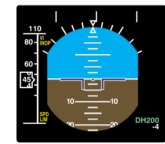
When flying a precision instrument approach in IMC, everything narrows to a single critical moment: reaching the lowest authorized point on the glidepath and deciding whether to continue to a landing or execute a missed approach. Two terms define this moment — Decision Altitude (DA) and Decision Height (DH). Though they describe the same fundamental concept, they differ in how they are referenced, which approach procedure they apply to, and how pilots use them in the cockpit. Confusing the two is a classic knowledge-test trap, but more importantly, misunderstanding them in actual IMC can be operationally dangerous.
This article breaks down each term precisely, explains the regulatory framework, compares the approach types that use each, and gives you the practical tools to apply them correctly both on the written exam and in the airplane.
What Is Decision Altitude?
Decision Altitude (DA) is expressed in feet above mean sea level (MSL). It is the published altitude on an instrument approach procedure at which a pilot flying a precision approach — or an approach with vertical guidance — must make a go/no-go decision. If the required visual references for the intended runway are not clearly visible and identifiable at DA, the pilot must immediately execute the published missed approach procedure.
The shift to MSL referencing happened when the FAA adopted terminology aligned with ICAO standards. Previously, the term Decision Height was used broadly, but modern U.S. approach charts now use DA for procedures that use baro-altimetry to define the vertical path — most notably, RNAV (GPS) approaches with LPV (Localizer Performance with Vertical Guidance) and LNAV/VNAV minima. These approaches provide electronic vertical guidance derived from GPS and WAAS or barometric inputs rather than a traditional ground-based glideslope transmitter. Because the pilot monitors altitude on the altimeter (referenced to MSL), the minimums are published in MSL.
For example, if an LPV approach has a DA of 1,240 feet MSL and the airport elevation is 800 feet MSL, the DA is 440 feet above the touchdown zone — but the chart simply states 1,240. The pilot monitors the altimeter, and when it reads 1,240, the decision must be made.
What Is Decision Height?
Decision Height (DH) is expressed in feet above ground level (AGL), specifically above the highest elevation in the touchdown zone of the runway. It applies to ILS (Instrument Landing System) approaches and other approaches that use an electronic glideslope transmitted from the ground, such as the MLS (Microwave Landing System) and the GLS (GBAS Landing System). Because the glideslope antenna and the altimeter system used in these operations are calibrated to the aircraft's height above the touchdown zone, the reference is AGL.
A standard Category I ILS has a DH of 200 feet AGL above the touchdown zone elevation. This means that regardless of the airport's MSL elevation — whether you are landing at a sea-level coastal airport or a 5,000-foot mountain airport — DH is always measured from the ground beneath you (specifically the touchdown zone), not from sea level. The pilot cross-checks the radio altimeter (if equipped and required for lower categories) or calculates the equivalent MSL altitude ahead of time and monitors the pressure altimeter.
For Cat I ILS approaches, most general aviation aircraft use the pressure altimeter to identify DH. To do this, pilots add the published DH (e.g., 200 feet AGL) to the Touchdown Zone Elevation (TDZE) found on the approach chart. If the TDZE is 630 feet MSL, the equivalent DA in MSL is 830 feet. Many pilots brief this MSL equivalent before the approach so the altimeter cross-check is instantaneous at the critical moment.
Why the Distinction Matters
The difference between MSL and AGL referencing is not just academic — it has real implications for safety and situational awareness. Consider these two scenarios:
- Terrain variation: An airport with uneven terrain near the runway may have a touchdown zone that sits considerably higher than the surrounding approach corridor. An AGL-referenced DH ensures the pilot's decision point is always a fixed height above the actual landing surface, regardless of the surrounding geography.
- Approach type and equipment: Flying an LPV approach to DA does not require a radio altimeter — the barometric altimeter suffices. Flying a Cat II ILS to a DH of 100 feet AGL, however, typically requires a calibrated radio altimeter that directly measures height above the terrain, because the precision required at that low height exceeds what a baro-altimeter alone can guarantee.
Understanding which term applies also helps you read charts correctly. Approach chart minimums boxes list either DA(H) or DH alongside the visibility requirement. The parenthetical notation DA(H) that appears on some charts is a reminder that the MSL value has a corresponding AGL height — it is not a new third category.
The Required Visual References
Reaching DA or DH does not automatically mean you can land. At that exact altitude or height, 14 CFR 91.175 requires that the pilot have distinctly visible and identifiable visual references from a specific list. These include elements such as the approach light system, the runway threshold, threshold markings, threshold lights, runway end identifier lights, the touchdown zone or its markings or lights, or the runway itself. If any of these are in sight and the aircraft is in a position to make a normal landing, the pilot may continue the descent below DA/DH. If none are visible, the missed approach must begin immediately — not after a few more feet of descent, and not after a hopeful look around.
This is a fundamental safety rule: you cannot descend below DA or DH in the hope of finding the runway. The decision must be made at that point, and it must result in a landing or a missed approach — there is no legal or safe middle ground.
Key Numbers and Rules
- Standard Cat I ILS DH: 200 feet AGL above the touchdown zone, with visibility typically ½ statute mile or RVR 2,400 feet.
- LPV DA: Can be as low as 200 feet AGL equivalent (DA expressed in MSL), rivaling Cat I ILS performance.
- LNAV/VNAV DA: Typically 300–400 feet AGL equivalent; uses barometric vertical navigation.
- Cat II ILS DH: 100 feet AGL; requires specific aircraft, pilot certification, and airport equipment.
- Cat III ILS DH: Below 100 feet AGL, or no DH at all (Cat IIIc); requires autoland and specific authorization.
- 14 CFR 91.175: Governs the requirement to have required visual references at DA/DH before descending further.
- TDZE: Touchdown Zone Elevation — always used to convert AGL DH to an MSL equivalent for altimeter monitoring.
- Radio altimeter: Required for Cat II and Cat III operations; measures true height above terrain directly beneath the aircraft.
DA vs. DH — Side-by-Side Comparison
- DA (Decision Altitude): MSL reference — used for RNAV/GPS approaches with vertical guidance (LPV, LNAV/VNAV), baro-altimeter monitored.
- DH (Decision Height): AGL reference — used for ILS, MLS, GLS approaches with electronic glideslope, radio altimeter used at lower categories.
- Same concept, different reference datum: Both represent the lowest point on the glidepath where the go/no-go decision must be made.
- Both governed by 91.175: The visual reference requirement and the prohibition against descending further without required references apply equally.
Common Test Traps
- Mixing up MSL and AGL: The most common error. DA is MSL; DH is AGL. The FAA knowledge test will offer answer choices with the wrong reference unit — always link the term to its datum before selecting.
- Assuming all precision approaches use DH: LPV approaches are classified as approaches with vertical guidance (APV) and use DA, not DH — even though their performance rivals a Cat I ILS. Only ground-based electronic glideslope approaches use DH.
- Descending below DA/DH to look for the runway: 14 CFR 91.175 prohibits this clearly. A test question may offer "continue descent for 50 feet to acquire the runway" as a plausible distractor — it is never correct.
- Forgetting to add TDZE to DH: When briefing an ILS approach on a pressure altimeter, pilots must compute DA equivalent (TDZE + DH) before the approach. Exam questions sometimes require this arithmetic or test whether you know why it is necessary.
- Confusing DA(H) notation with a separate minimums category: The parenthetical "(H)" in DA(H) simply reminds you that the MSL value corresponds to an AGL height — it does not create a third type of decision point.
Mastering the distinction between DA and DH is a foundation of precision approach flying. When you brief an approach, identify which term the chart uses, confirm your reference datum, compute any MSL equivalents you need, and know exactly what visual references you must have in sight before that critical altitude arrives. That clarity — practiced on the ground — becomes instinct in the clouds.