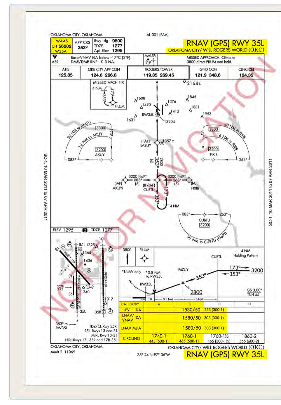
When you pull up an RNAV (GPS) approach plate, you will notice something that sets it apart from older non-precision approaches: a stack of minima lines, each labeled differently, each requiring different equipment, and each offering a different set of minimums. Understanding why those lines exist, what separates them, and which one your aircraft and avionics qualify for is not just an academic exercise — it is one of the most frequently tested topics on the FAA Instrument Rating knowledge exam and, more importantly, one of the most consequential decisions you will make during an actual IFR flight.
This article breaks down the three primary minima lines found on RNAV (GPS) approach charts — LPV, LNAV/VNAV, and LNAV — explaining the underlying technology, the regulatory requirements, and the practical differences in how you fly each. We will also cover what the minima numbers actually mean and where you are most likely to get tripped up on a test or in real operations.
The Architecture of an RNAV (GPS) Approach
Area Navigation (RNAV) approaches use GPS satellite signals — sometimes augmented by ground-based or satellite-based systems — to guide an aircraft along a defined lateral path to a runway. The FAA publishes these as RNAV (GPS) approaches, and a single chart can legally serve aircraft with very different equipment levels. Rather than publishing separate approach charts for each equipment type, the FAA stacks multiple sets of minimums on one plate. The line you fly to depends entirely on what your avionics can support and what you are trained and authorized to use.
The three main minima lines are arranged from lowest (best) minimums at the top to highest (least favorable) at the bottom. This ordering reflects the decreasing level of precision and vertical guidance available to each category of equipment.
LPV: Localizer Performance with Vertical Guidance
LPV stands for Localizer Performance with Vertical Guidance. Despite the name, LPV is not an ILS and does not use a localizer antenna. It is a GPS-based approach that uses the FAA's Wide Area Augmentation System (WAAS) — a network of precisely surveyed ground reference stations and geostationary satellites — to provide both horizontal and vertical corrections to the GPS signal. This augmentation dramatically tightens the accuracy of the position solution, enabling angular guidance similar to a Category I ILS.
Because WAAS-based LPV approaches use angular course deviation (not a fixed lateral width), the guidance becomes more sensitive as you approach the runway, exactly like an ILS localizer and glideslope. The final approach course width narrows to about 700 feet at the runway threshold on a typical LPV, and the vertical guidance drives you down a glidepath — typically 3 degrees — to a Decision Altitude (DA). This is a critical distinction: LPV uses a DA, not a Minimum Descent Altitude (MDA). At the DA, you must either see the runway environment and commit to landing, or immediately execute the missed approach.
LPV minimums can be as low as 200 feet HAT (Height Above Touchdown) with a half-mile visibility — equivalent to a full Category I ILS — though many LPV approaches have somewhat higher minimums depending on terrain, obstacles, and approach design. To fly to LPV minimums, your aircraft must be equipped with a WAAS-capable GPS navigator (confirmed via the aircraft flight manual supplement and the equipment list), and the system must annunciate LPV as the active approach mode before the final approach fix. If your WAAS receiver annunciates LNAV instead of LPV at the FAF — possibly due to satellite geometry or WAAS signal outage — you must immediately apply the LNAV minimums rather than the LPV minimums.
LNAV/VNAV: Lateral Navigation / Vertical Navigation
LNAV/VNAV is the middle tier. It provides both lateral and vertical guidance but with wider tolerances and a different technical source than LPV. There are two main ways an aircraft can qualify for LNAV/VNAV:
- Baro-VNAV: Many modern Flight Management Systems (FMS) can compute a geometric vertical path using barometric altitude data. This is called baro-VNAV. The system essentially calculates a constant-angle descent path to the runway and provides vertical deviation guidance on the primary flight display, but the accuracy of that vertical guidance depends on the aircraft's altimeter being accurate and correctly set, and on temperature compensation where required. Cold temperatures can cause significant errors because baro-altimeters read higher than actual altitude in cold air, potentially producing a terrain hazard. Many LNAV/VNAV approaches therefore have temperature restrictions or require crews to apply cold-temperature corrections per the AIM.
- WAAS with degraded vertical performance: A WAAS receiver that cannot support LPV accuracy (perhaps due to a marginal satellite constellation) may still support LNAV/VNAV. The avionics will annunciate accordingly.
Like LPV, LNAV/VNAV uses a DA — the vertical path is continuous, and the decision to land or go missed is made at a specific altitude, not after leveling off. However, LNAV/VNAV minimums are typically higher than LPV minimums on the same plate, often 250–400 feet HAT, because the vertical accuracy is not as tight. The lateral accuracy for LNAV/VNAV is the same as standard LNAV — essentially the GPS RNP 0.3 standard during the approach segment, giving an angular or width-defined corridor.
Pilots must confirm their aircraft's AFM/AFMS explicitly approves baro-VNAV or WAAS LNAV/VNAV operations. Simply having a GPS does not automatically authorize LNAV/VNAV minimums.
LNAV: Lateral Navigation Only
LNAV is the baseline GPS approach and requires only a GPS receiver approved for IFR approaches under TSO-C129 or TSO-C196. WAAS is not required, though a WAAS unit can fly LNAV minimums as well. LNAV provides only lateral guidance — there is no vertical deviation needle from the avionics. The pilot descends to a Minimum Descent Altitude (MDA) and then flies level at that altitude, looking for the runway environment.
Because LNAV uses an MDA rather than a DA, the technique differs. You descend to the MDA, level off, and continue flying until you either identify the runway environment in sufficient time to make a normal landing, or you reach the Missed Approach Point (MAP). The MAP on an LNAV approach is typically defined by a waypoint at or near the runway threshold. LNAV minimums are the highest (least favorable) on the plate, commonly 300–500 feet HAT or more, with visibility requirements of three-quarters of a mile or greater depending on the approach.
One important nuance: even without vertical avionics guidance, pilots may choose to fly a Continuous Descent Final Approach (CDFA) technique on an LNAV approach. Using CDFA, you calculate and fly a constant-angle descent path manually (using VSI, groundspeed, and a target descent rate) as if it were a glidepath, treating the MDA as a DA in practice. This technique, endorsed in the Instrument Flying Handbook, significantly improves situational awareness and reduces the risk of a dive-and-drive profile that could lead to a CFIT accident.
Why These Distinctions Matter
The difference between a 200-foot DA on an LPV approach and a 400-foot MDA on an LNAV approach can mean the difference between landing safely and flying the missed approach at a destination with rapidly deteriorating weather. When the field is reporting a 300-foot broken ceiling and a mile visibility, an LNAV-only pilot is going missed while the LPV-equipped pilot is landing. That real-world consequence is exactly why the FAA tests these distinctions so heavily.
There are also safety implications around vertical guidance. Approach accidents are overwhelmingly associated with non-precision approaches using the dive-and-drive technique. LNAV/VNAV and LPV approaches, because they provide or encourage a constant vertical path, have a dramatically better safety record. The FAA has invested heavily in WAAS infrastructure precisely to push as many approaches as possible toward LPV capability.
Key Numbers and Rules
- LPV: Requires WAAS-capable GPS; uses DA; angular guidance narrows to approximately 700 ft at threshold; minimums can reach 200 ft HAT / ½ SM visibility.
- LNAV/VNAV: Requires WAAS or FMS baro-VNAV (per AFM/AFMS); uses DA; minimums typically higher than LPV but lower than LNAV; check temperature restrictions for baro-VNAV.
- LNAV: Requires TSO-C129 or TSO-C196 IFR-approved GPS; uses MDA; lateral guidance only; highest minimums on the chart.
- If the avionics annunciate LNAV instead of LPV at the FAF, apply LNAV minimums immediately — never fly to LPV minimums if the receiver cannot support them.
- Cold temperature errors affect baro-VNAV; the AIM provides cold-temperature correction tables and procedures.
- CDFA is recommended technique for LNAV approaches: select an appropriate angle (typically 3°), descend continuously, and treat the MDA as a DA for go/no-go decision.
Common Test Traps
- DA vs. MDA confusion: LPV and LNAV/VNAV use a Decision Altitude (DA) — you decide at that altitude. LNAV uses a Minimum Descent Altitude (MDA) — you level off there. The FAA frequently tests whether you know which term applies to which minima line.
- Assuming WAAS always gives LPV: A WAAS receiver may annunciate LNAV/VNAV or even plain LNAV if satellite geometry or signal quality is insufficient for LPV. Always verify the annunciation at the FAF.
- Confusing LPV with an ILS: LPV provides ILS-like angular guidance but is GPS/WAAS-based, has no localizer antenna, and is not a precision approach under ICAO definitions (it is an APV — Approach with Vertical Guidance). On the exam, it is categorized as an approach with vertical guidance, not a precision approach.
- Baro-VNAV temperature limitations: Students forget that cold temperatures cause the aircraft to fly below the computed path when using baro-VNAV, requiring corrections. The FAA tests this as a cold-weather altitude error.
- Equipment authorization: Having a GPS in the panel does not automatically mean you can fly LNAV/VNAV or LPV. The AFM or AFMS must specifically authorize the approach type. Airworthiness and currency of the GPS database must also be confirmed.